|
Great Smoky Mountain National Park Elevations Map, Maps, Photo, Photographs,
Pictures, What are the Smoky Mountain Elevations? Smoky Mountains Peaks Heights, Photos Smokies Peak Heights, Smoky Mountain
Peak Elevations
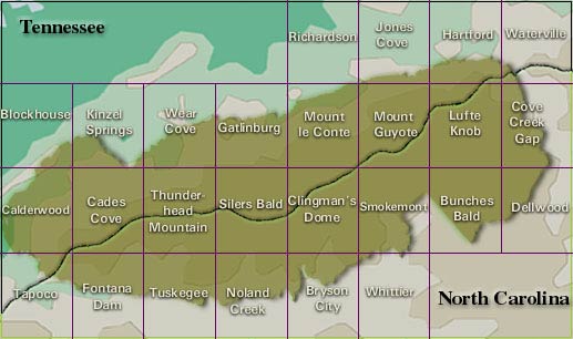
Great Smoky Mountain National Park Elevations
ELEVATIONS IN THE PARK
The crest of the Great Smokies runs in an unbroken
chain of peaks that rise more than 5,000 feet for over 36 miles. Elevations in the park range from 876 to 6,643 feet.
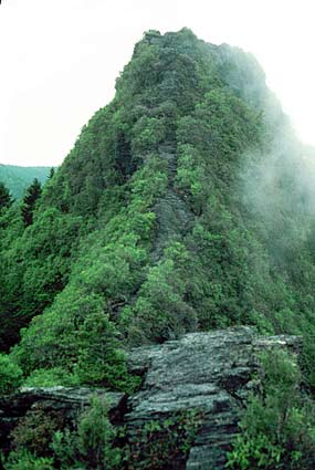
| Chimney Tops |
|
| NPS |
The Top 10 Peaks (elevation in feet)
Clingmans Dome - 6,643
Mount
Guyot - 6,621
Mount Le Conte (High Top) - 6,593
Mount Buckley - 6,580
Mount Love - 6,420
Mount Chapman - 6,417
Old Black - 6,370
Luftee Knob - 6,234
Mount Kephart - 6,217
Mount Collins - 6,118
Elevations of Popular Destinations (in feet)
Andrews Bald
- 5,920
Charlies Bunion - 5,565
Balsam Mountain Campground - 5,310
Newfound Gap - 5,046
Alum Cave Bluffs -
4,970
Spence Field - 4,920
Chimney Tops - 4,800
Rainbow Falls - 4,326
Ramsey Cascades - 4,275
Grotto Falls
- 3,770
Cataloochee Valley - 2,680
Laurel Falls - 2,600
Smokemont Campground - 2,198
Elkmont Campground - 2,150
Little
Greenbrier School - 2,070
Oconaluftee Visitor Center - 2,040
Cades Cove Visitor Center - 1,716
Fontana Dam - 1,709
Abrams
Falls - 1,473
Sugarlands Visitor Center - 1,462
Abrams Creek at park boundary - 876
| Great Smoky Mountain National Park |
|
| LOC |
Clingmans Dome
At 6,643 feet, Clingmans Dome is the highest point in the Great Smoky
Mountains National Park. It is the highest point in Tennessee, and the third highest point in the Appalachian Mountain range.
Only Mt. Mitchell (6,684 feet) and Mt. Craig (6,647), both located in Mt. Mitchell State Park in western North Carolina, rise
higher.
Clingmans Dome is a popular park destination. Spectacular vistas await those
willing to climb the steep half-mile walk to the tower at the top. On clear, pollution-free days, views expand over a
100 miles. Unfortunately, air pollution often limits viewing distances to under 20 miles.
Clouds, precipitation, and cold temperatures reveal the hostile environment
atop Clingmans Dome. Proper preparation is essential for a good visit. Although Clingmans Dome is open year-round, the road
leading to it is closed from December 1 through March 31, and whenever weather conditions require.
What's killing the trees? The balsam woolly adelgid (Adelges piceae)
is an insect pest that infests and kills stands of Fraser fir (Abies fraseri) in the spruce-fir zone. This fir occurs
naturally only in the southern Appalachians and used to be the dominant tree at the highest elevations. The adelgid was introduced
on trees imported from Europe, and the fir has little natural defense against it. By injecting the tree with toxins, the adelgid
blocks the path of nutrients through the tree. The trees literally starve to death, and thousands of dead snags are all that
are left on the highest mountain peaks.
Highlights:
There are several trails that start on Clingmans Dome Road and
parking area. The Appalachian Trail (AT) crosses Clingmans Dome, marking the highest point along its journey from Georgia
to Maine.
Cool, wet conditions on Clingmans Dome's summit make the spruce-fir forest
that grows there a coniferous rainforest.
Catch a breathtaking sunrise or sunset from the tower or enjoy the 360º panoramic
vistas during the day.
Newfound Gap
At an elevation of 5,048 feet, Newfound Gap
is the lowest drivable pass through the Great Smoky Mountains National Park. Newfound Gap's recognition as the lowest pass
through the Great Smoky Mountains did not come until 1872. Arnold Henry Guyot, a Swiss geographer, measured many Southern
Appalachian elevations. Mt. Guyot, the second highest peak in the Smokies, takes his name. He used a simple barometer to measure
changes in air pressure to calculate mountain heights. In most cases he was within 2-3 percent of current values. His work
revealed Newfound Gap as the lowest pass through the mountains, displacing nearby Indian Gap. A new road followed, and it
became the forerunner of Newfound Gap Road.
Highlights:
Rockefeller Memorial honors a $5 million donation from the
Rockefeller Foundation to help complete land acquisitions to bring about the creation of the Great Smoky Mountains National
Park.
Scenic views from the large parking area.
The Appalachian Trail (AT)
crosses over Newfound Gap Road and straddles the state line between North Carolina and Tennessee for most of its length through
the park. Visitors can enjoy a short stroll to stretch their legs or a multi-day backpacking excursion on the AT
as it runs through the park.
Recommended Reading: The United States of Appalachia: How Southern Mountaineers Brought
Independence, Culture, and Enlightenment to America.
Description: Few places in the United States confound and fascinate Americans like Appalachia,
yet no other area has been so markedly mischaracterized by the mass media. Stereotypes of hillbillies and rednecks repeatedly
appear in representations of the region, but few, if any, of its many heroes, visionaries, or innovators are ever referenced.
Continued below...
Make no mistake,
they are legion: from Anne Royall, America's first female muckraker, to Sequoyah, a Cherokee mountaineer who invented the
first syllabary in modern times, and international divas Nina Simone and Bessie Smith, as well as writers Cormac McCarthy,
Edward Abbey, and Nobel Laureate Pearl S. Buck, Appalachia has contributed mightily to American culture — and politics.
Not only did eastern Tennessee boast the country's first antislavery
newspaper, Appalachians also established the first District of Washington as a bold counterpoint
to British rule. With humor, intelligence, and clarity, Jeff Biggers reminds us how Appalachians have defined and shaped the
United States we know today.
Recommended Reading:
Touring the Western North Carolina Backroads (Touring the Backroads). Editorial Review: This guidebook, unlike most,
is so encyclopedic in scope that I give it as a gift to newcomers to the area. It is also an invaluable reference for the
visitor who wants to see more than the fabulous Biltmore Estate. Even though I am a native of the area, I learned nearly everything
I know about Western
North Carolina from this book alone and it is my primary reference. I am still amazed at how much fact, history
and folklore [just enough to bring alive the curve of the road, the odd landmark, the abandoned building] is packed in its
300 pages. The author, who must have collapsed from exhaustion when she finished it, takes you on a detailed tour, laid out
by the tenth of the mile, of carefully drawn sections of backroads that you can follow leisurely without getting lost. Continued
below...
The author is completely absent from the text. The lucid style will please readers who want the facts, not
editorial comment. This book, as well as the others in this publisher's backroads series, makes an excellent gift for anyone,
especially the many seniors who have relocated, or are considering relocating to this fascinating region. It is also a valuable
reference for natives, like me, who didn't know how much they didn't know.
Recommended Reading: Touring the East Tennessee Backroads (Touring the Backroads) (380 pages)
(John F Blair Pub; 2 edition) (October 1, 2007). Description: The historical facts in the first edition of Touring the East Tennessee Backroads have not changed much since the
book was first published in 1993, but highway construction and development has altered the routes of the 13 tours. For this
second edition, the author drove over 3,000 miles to update the tours where people such as Daniel Boone, Davy Crockett, Sam
Houston, Andrew Jackson, Sequoyah, Nancy Ward, and Clarence Darrow once traveled the same backroads.
Recommended Reading: Our Southern Highlanders: A Narrative of Adventure in the Southern Appalachians and
a Study of Life Among the Mountaineers (548 pages). Description: A narrative of adventure in the southern Appalachians and a study of
life about the mountaineers. Horace Kephart is the man most responsible for the existence of the Great
Smoky Mountain National
Park spanning the North Carolina and Tennessee
border. Continued below...
Using his numerous
journals, he wrote of first-hand observations of the mountains and people during his 10 years of travels through the Appalachians. 6x9 trade
paper, 548 pages. Includes foreword by Ralph Roberts.
Recommended Reading: Appalachia: A History
(496 pages) (The University of North Carolina Press). Description: Interweaving social, political, environmental, economic, and popular history, John Alexander Williams chronicles
four and a half centuries of the Appalachian past. Along the way, he explores Appalachia's long-contested boundaries and the
numerous, often contradictory images that have shaped perceptions of the region as both the essence of America and a place apart. Williams begins his story in the
colonial era and describes the half-century of bloody warfare as migrants from Europe and their American-born offspring fought
and eventually displaced Appalachia's Native American inhabitants. Continued below…
He depicts
the evolution of a backwoods farm-and-forest society, its divided and unhappy fate during the Civil War, and the emergence
of a new industrial order as railroads, towns, and extractive industries penetrated deeper and deeper into the mountains.
Finally, he considers Appalachia's
fate in the twentieth century, when it became the first American region to suffer widespread deindustrialization, and examines
the partial renewal created by federal intervention and a small but significant wave of in-migration. Throughout the book, a wide range of Appalachian voices enlivens the analysis and
reminds us of the importance of storytelling in the ways the people of Appalachia define
themselves and their region.
He or she
who cares deeply about this region needs this book.
(Blue Ridge Country)
An outstanding
interpretation of Appalachian history. Williams's explanations on many topics are the best presently available from any publication.
(Author/historian Gordon B. McKinney, Berea College
|