|
North Carolina Blue Ridge Parkway Map
Asheville to Great Smoky Mountains Scenic Drive
| North Carolina: Blue Ridge Parkway South Map |
|
| Courtesy weather.com |
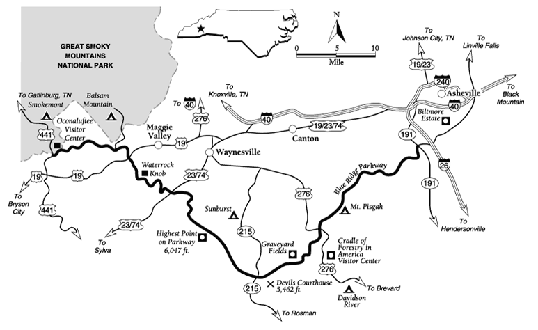
General description: A 75-mile paved section of one
of the most famous routes in America, following the dramatic crest of the Pisgah and Great Balsam Mountains to Great Smoky
Mountains National Park.
Location: Southwestern North Carolina. The drive starts on the
southwest side of Asheville, at the junction of the Blue Ridge Parkway and NC 191. To get there from I-26, take Exit 2 and
follow NC 191 south about 2.5 miles.
Drive route name: Blue Ridge Parkway.
Travel season: Spring through fall is best. Snow and ice can
close the parkway in winter.
Special attractions: Blue Ridge Parkway, Pisgah National Forest,
Devils Courthouse, Graveyard Fields, Shining Rock Wilderness, Middle Prong Wilderness, Cherokee Indian Reservation, Great
Smoky Mountains National Park, hiking, scenic views, fall colors.
Camping: The National Park Service maintains campgrounds at Mount
Pisgah, at Balsam Mountain, and Smokemont in Great Smoky Mountains National Park. The Pisgah National Forest manages several
campgrounds within a few miles of the parkway.
Services: All services are available in Asheville, Mount Pisgah,
and Cherokee.
Nearby attractions: Other sections of Great Smoky Mountains National
Park and the Pisgah National Forest, other segments of the Blue Ridge Parkway, Nantahala National Forest, Cradle of Forestry
in America, Looking Glass Falls, Looking Glass Rock, and Biltmore Estate.
The drive: The Blue Ridge Parkway is one of the premier
drives in the United States. It generally follows the crest of the Blue Ridge and other Appalachian mountains for 469 miles,
from Shenandoah National Park in Virginia to Great Smoky Mountains National Park in North Carolina, Virginia, and Tennessee.
Driving the entire route takes several days if you want to see its many sights. Even this 75-mile segment of parkway, the
southernmost section, can take more than a day if you spend a lot of time hiking and taking side trips.
This route travels from the southwest side of Asheville to Great Smoky Mountains
National Park, both worthy destinations in themselves. Drive 2 describes the section of parkway just north of this one, from
Blowing Rock to Asheville. Between Asheville and the Smokies, the Blue Ridge Parkway reaches its highest point (6,047 feet)
and some of its most spectacular views. It crosses a large portion of public lands in the Pisgah and Nantahala National Forests,
leading to exceptional opportunities for hiking, fishing, camping, and other activities.
Start the drive on the edge of Asheville where the parkway crosses NC 191
and the French Broad River, a large waterway flowing west toward Tennessee. The river's wide banks encouraged its use as a
travel route through these mountains during the early days of area settlement. In warm weather you may see boaters floating
downstream here. The parkway's first overlook, on your left, offers good views of the river and boaters.
From here, at about 2,000 feet above sea level, the parkway climbs and climbs.
It enters the Pisgah National Forest almost immediately. The 87,000-acre heart of this forest unit was once part of the Biltmore
Estate, established by George Vanderbilt (see Drive 2). The U.S. government purchased the land after Vanderbilt's death in
1914. As you continue up the road, you will get occasional views back toward Asheville and the old Biltmore Estate.
By the time you arrive at Chestnut Cove Overlook in another 4.9 miles, you
will have climbed to an altitude of 3,035 feet. Until 1904, the American chestnut was one of the dominant trees in this cove.
In that year, a blight introduced in New York City began wiping out all the chestnuts in America. A favorite shade tree, the
chestnut provided wood for split-rail fences like those seen along the parkway. Both humans and wildlife ate its flavorful
nuts. Today, chestnuts that sprout from old root systems still cannot survive the blight. Forest specialists are trying to
hybridize a resistant variety.
Drivers along this stretch will have passed through the Grassy Knob Tunnel
before reaching Chestnut Cove. Now, in less than a mile, you will reach Pine Mountain Tunnel. At 1,462 feet long, this tunnel
is the longest of the 26 found on the parkway. All but one of the tunnels lie in the southernmost 136 miles of the parkway;
18 of them lie along this segment alone. Only one tunnel is in Virginia, near the parkway's northern end.
The parkway next climbs a long ridge leading to Mount Pisgah, with numerous
overlooks and tunnels. Drivers pass the 4,000-foot mark just before the Mills River Valley Overlook, about 11 miles into the
drive. The river that runs far below this overlook was named for William Mills, an early settler in the area. In the early
1800s, Mills saw an elk near the river; it was the last reported elk in North Carolina. Even in the early nineteenth century,
mankind had a significant impact on this natural area.
The road continues to climb. In another 3 miles, it reaches the 4,995-foot
Mount Pisgah parking area. Mount Pisgah was named for the biblical mount from which Moses first viewed the Promised Land after
leading his people out of slavery in Egypt. From the parking area, a moderately strenuous hiking trail climbs more than 700
feet to the mountain's summit. One mile beyond the parking area is Pisgah Lodge on the mountain crest. With attendant great
views, visitors can find food, lodging, gas, campsites, a picnic area, and a gift shop here. The lodge tends to book up early,
so reserve a room ahead of time if you want to stay.
The parkway now follows the crest of the mountains on a nearly level route.
Look for the Frying Pan Fire Lookout tower on a ridge above the road, a little past the lodge. After some distance, The Cradle
of Forestry Overlook appears on the left. Signs at this overlook tell about the birth of modern forestry in the valley far
below when it was part of the Biltmore Estate. About 0.8 mile past the forest overlook, drivers reach the junction with US
276. If you do not plan to drive the entire Forest Heritage Scenic Byway (Drive 10), consider making a short side trip down
US 276 south toward Brevard to the Cradle of Forestry in America Visitor Center. The center's historic buildings, displays,
and living history demonstrations are all very interesting.
Pigeon Gap lies less than a mile past the US 276 junction. Passenger pigeons
once flew through here in immense flocks that sometimes numbered in the millions. Hunting and possibly diseases from domestic
fowl led to their extinction early in this century. The area along the road to the right after the gap is part of the Shining
Rock Wilderness, a 19,000-acre preserve favored by hikers and backpackers. Many miles of trails wind through its high peaks
lush forests, and past rushing streams.
An overlook about 5 miles from the US 276 junction offers a good view of Looking
Glass Rock. This rocky knob lined with curving cliffs got its name from the sparkling reflections it gives off when wet or
icy. Hikers and rock climbers love this peak, which is accessible from trails along Drive 10. In another 1.9 miles, a pullout
marks the site of Graveyard Fields. Much of the area here is open or brushy. In 1925, after a long dry spell, hunters started
a fire here on Thanksgiving Eve. Burning out of control, it decimated 25,000 acres. The blaze destroyed standing trees, cut
timber, logging camps, and slash piles. The fire was so hot that it burned up stumps, roots, and much of the soil itself.
Because it so damaged the soil, the area has been slow to recover. Graveyard Fields is a well-known hiker destination because
it offers easy access to the Shining Rock Wilderness and high peaks such as 6,214-foot Black Balsam Knob. Another area attraction
is Yellowstone Prong (a prong is a creek), visible below the road. The Graveyard Fields Loop Trail leads to three attractive
waterfalls and many smaller cascades. In summer, don't expect to have this popular area to yourself.
After another 1.4 miles of parkway, you will pass another trailhead
on the right. Routes lead from here to the Shining Rock Wilderness. Another popular
parkway stop, known as the Devils Courthouse, follows in 2.2 miles. Legend tells us that the Devil holds court in a cave within
the bowels of this mountain. The Cherokee people also speak of a "nice" devil in this place. According to their story, a giant
named Judaculla sat in judgment here, condemning people who lacked courage or strayed from virtue (Native American and Cherokee Indian: Rock Art, Stone Symbols, Myths,
Legends, and Signs). The Devils Courthouse viewpoint lies at 5,462 feet. A short trail climbs
nearly 300 feet to the knob's summit. The top is bare and rocky; without trees to get in the way, the 360-degree views are
incredible.
In less than a mile, the parkway reaches
Beech Gap and NC 215, which is part of the Forest Heritage Scenic Byway (Drive 10). Beyond Beech Gap the parkway turns
northwest and passes between two prominent peaks, Mount Hardy and Tanasee Bald. Great views are plentiful in the next few
miles as you travel along the crest of the Great Balsam Mountains. Along the right (north) side of the road, the Middle Prong
Wilderness contains rugged terrain. The Cowee Mountains Overlook, about 7.4 miles past the NC 215 junction, gives visitors
an impressive panorama of the mountains and valleys to the south and west.
The road soon climbs to an elevation of more than 6,000 feet and reaches the
highest point on the entire Blue Ridge Parkway at 6,047-foot Richland Balsam Overlook. Nearby Richland Balsam Mountain is
the highest peak in the Great Balsams, rising 6,410 feet. If you hike the short nature trail that leaves from the overlook,
wear a sweater; it's usually quite cool up here, even in summer. The surrounding forest of Fraser fir and red spruce indicates
a cool, wet climate. During cooler times, such as during the last ice age, this Canadian-type forest grew farther down the
mountain slopes. As the climate warmed, the trees retreated upward to scattered high peaks and ridges. Sadly, as is obvious
here, many of the Southern Appalachian firs are dying from an insect pest known as the balsam woolly adelgid. The red spruces
are also not very healthy, victims of acid rain.
From Richland Balsam Overlook, the parkway begins to head downhill. The town
of Waynesville and a large, ugly quarry soon become visible below you, on the right. The town is noted for its apple orchards.
After a long, 12.5-mile descent, you will reach a low point of 3,370 feet at Balsam Gap. The gap has long been a travel route
across the Great Balsam Mountains and was used by the Cherokees before Europeans arrived. Later settlers adopted the route
when they arrived on the scene. In 1883, the Southern Railroad built a line through the gap, the highest point on a standard-gauge
railroad in the eastern United States. Busy US 23/US 74 also crosses the gap and the parkway here. After traveling down the
quiet parkway, the roar of trains and heavy traffic here can be a bit of a shock.
From Balsam Gap, the parkway once again begins a long climb, reaching a second
high point in 7.6 miles. Here, at 5,718-foot Waterrock Knob Overlook, visitors can look at exhibits, walk a trail, and find
a bathroom. Waterrock Knob rises in the distance to 6,292 feet, making it the second highest peak in the Great Balsam Mountains.
It also marks the point where the Plott Balsam Mountains join the Great Balsams. The knob was named for a popular spring that
once poured over the rock. Not surprisingly, the all-encompassing view from the top is wonderful.
From Waterrock Knob, the parkway descends once again, this time to Soco Gap
and a junction with busy US 19. Like other similar gaps, this one has long been a popular travel route. The Cherokee people
remember the gap as a place where they ambushed and defeated a large group of invading Shawnees in the mid-1700s. From Soco
Gap, the parkway climbs yet again, reaching the boundary of the Cherokees' Qualla Reservation in about 1.8 miles. A series
of wars with white settlers and other Indian tribes pushed the Cherokees out of North Carolina by 1838. They were forcibly
removed to a reservation in Oklahoma via the well-named Trail of Tears. During the removal, a band of refugees hid in these
mountains while their white agent, Will Thomas, purchased land for them. In time they were allowed to return to this land,
which makes up part of the present-day reservation.
About 2.7 miles from Soco Gap, the parkway arrives at 5,100-foot Wolf Laurel
Gap. Here Balsam Road leads into Great Smoky Mountains National Park, where there is a campground, picnic area, hiking trails,
overlooks, and a back route to the town of Cherokee. Beyond this junction, the parkway descends through the reservation, dropping
off the Balsam Range past overlooks and through tunnels. In about 11 miles, the parkway ends after crossing the Oconaluftee
River at Newfound Gap Road. You are now in Great Smoky Mountains National Park. You can turn left to go a short distance into
the busy tourist town of Cherokee, or turn right to get to the Oconaluftee Visitor Center and a route into the heart of the
park.
Credit: weather.com
(visit weather.com for all your weather and travel needs); Adapted from the FalconGuide Scenic Driving North Carolina
by Laurence Parent.
Recommended
Reading: Scenic Driving North
Carolina,
2nd, by Laurence Parent (Scenic Driving Series). Description: Pack up the car and enjoy
thirty drives through some of the most spectacular scenery in the Tar Heel State. This indispensable highway companion maps
out trips for exploring scenic byways and side roads, from the deep forests and breathtaking views of the Blue Ridge Parkway
to the majestic lighthouses and historic villages of the Outer Banks, from the lush rolling country of the Piedmont to the
rugged terrain of the Appalachian Mountains. Continued below…
Inside you'll
find: Itineraries ranging from 10 miles to more than 115 miles in length; Route maps for each drive; Where to find treasures
such as windswept dunes, mountain streams, magnificent fall colors, roaring waterfalls, and local wildlife; Historical information
and suggested side trips; Tips on camping, travel services, and best driving seasons. About the Author: Laurence Parent is
a freelance photographer and writer specializing in landscape, travel, and nature subjects. He has written twenty-one books,
including seven FalconGuides. He resides in Wimberley,
Texas.
Recommended
Reading: North Carolina Atlas & Gazetteer (North Carolina Atlas and Gazetteer). Description:
This is not your ordinary map! This Atlas is filled with comprehensive and detailed maps. It covers all three Regions of North
Carolina: Coastal Plain, Piedmont, and Mountains. It is the first choice for outdoor enthusiasts
– sports, hiking, fishing, rock climbing, skiing, boating, bird watching, tubing, kayaking, hunting, etc. “Beautiful,
detailed and large-format…” (1) Physical land features: topographic contours, water resources, vegetation, etc.
(2) Off-road options: trails, abandoned railroads, ferries. (3) Recreation: Parks, outdoor sports, points of interest. It
is perfect for home and office reference, the casual and business traveler, and every vehicle. Continued below...
Gazetteer information
even includes: campgrounds, attractions, historic sites & museums, recreation areas, trails, freshwater fishing sites
& boat launches, canoe trips or scenic drives. Reviews: “I am a full-time fishing guide in the mountains of North Carolina and I have found this book to be the absolute best reference
material for finding trout streams in our mountains. If you do any type of outdoors activities you will benefit from this
book.” “Instead of purchasing numerous cumbersome North Carolina
maps and atlases, I bought the North Carolina Atlas & Gazetteer and I am very pleased – it is definitive, complete,
and all-in-one.” “My wife and I recently retired and started traveling, as we always dreamed about doing, and
the numerous detailed pages in this Atlas saved us time and money while traveling across the beautiful state of North Carolina…we
were able to find those out of the way flea-markets, historic landmarks, and small town museums. I highly recommend it.”
Recommended Reading: Touring the Western North Carolina Backroads (Touring
the Backroads). Editorial Review: This guidebook, unlike
most, is so encyclopedic in scope that I give it as a gift to newcomers to the area. It is also an invaluable reference for
the visitor who wants to see more than the fabulous Biltmore Estate. Even though I am a native of the area, I learned nearly
everything I know about Western North Carolina from this book alone and it is my primary
reference. I am still amazed at how much fact, history and folklore [just enough to bring alive the curve of the road, the
odd landmark, the abandoned building] is packed in its 300 pages. The author, who must have collapsed from exhaustion when
she finished it, takes you on a detailed tour, laid out by the tenth of the mile, of carefully drawn sections of backroads
that you can follow leisurely without getting lost. Continued below...
The author
is completely absent from the text. The lucid style will please readers who want the facts, not editorial comment. This book,
as well as the others in this publisher's backroads series, makes an excellent gift for anyone, especially the many seniors
who have relocated, or are considering relocating to this fascinating region. “It is also a valuable reference for natives…”
|