|
North Carolina and Tennessee Scenic Drive
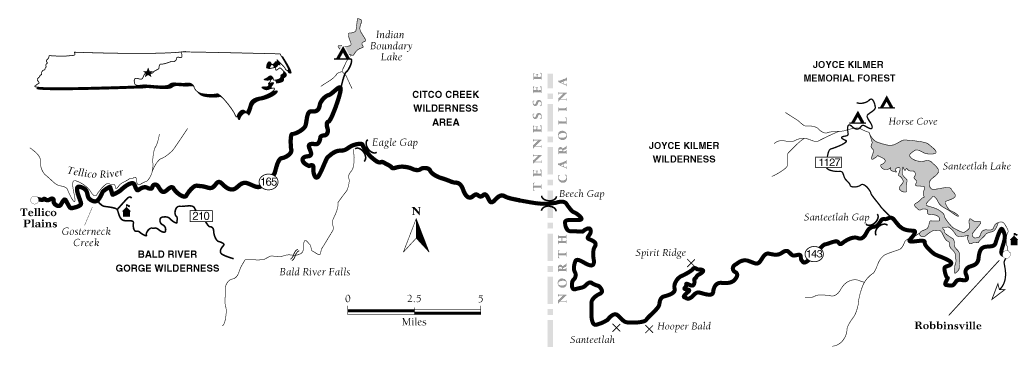
North Carolina Overhill Skyway Map
| North Carolina: Overhill Skyway Map |
|
| Courtesy weather.com |
General description: A winding, 44-mile paved route
through the southern Appalachian Mountains, through the ancestral territories of the Cherokee Indian nation. This route is
called the Cherohala Skyway by the Federal Highway Administration.
Location: Southeast Tennessee and southwest North Carolina on
the Cherokee and Nantahala national forests.
Byway route numbers: Tennessee State Highway 165 and North Carolina
Route 143.
Travel season: Year-round. Occasional temporary closures due
to snow or ice.
Special attractions: Three wildernesses: Bold River Gorge, Citico
Creek, and Joyce Kilmer Slickrock; whitewater sports, scenic overlooks, nature trails, camping, hunting, backpacking, bicycling.
Camping: Two campgrounds with toilets, drinking water, fire rings.
Services: All services in Tellico Plains and Robbinsville.
Nearby attractions: Ocoee National Forest Scenic Byway, Ocoee
Whitewater Center, Great Smoky Mountains National Park, Coker Creek Village, Fort Loudoun, L and N Depot and Railroad Museum,
Englewood Textile Museum.
The drive: The Overhill Skyway originates in the
Great Valley of Tennessee and traverses the Unicoi Mountain Range during its journey across the southern Appalachian Range
in Tennessee and North Carolina. The two-lane road is paved and has frequent turnouts and overlooks. Weekends along the entire
byway are generally busy. Weekends in spring, summer, and fall are extremely busy along the popular Tellico River and parking
can be difficult to find.
Summer visitors can expect variable weather, with temperatures ranging from
the mid 70s to the mid 90s. The area is humid and has an average annual rainfall of 52.6 inches.
The southern Appalachians are composed of some of the oldest exposed rocks
in the world, from the Precambrian and the Paleozoic ages. About 200 million years ago the collision of continents forced
these mountains upward, during what is now known as the Appalachian orogeny. The skyway offers unparalleled views of the southern
Appalachians.
Ancient Cherokee trading routes crossed these "Over the Hill Mountains," also
known over the years as Enemy Mountains, and White, or Smoky Mountains. Today's citizens celebrate the connection with an
annual week-long wagon train trek between Robbinsville and Tellico Plains.
These mountains and valleys have been inhabited or visited for 11,000 years.
They are the ancestral home of the Cherokee Indians, who by the time of European exploration and settlement had developed
sophisticated social and political systems, with agricultural economies based on corn, squash, and beans. About 22,000 Cherokees
lived in about 80 towns in the southern Appalachians, with the heart of the Cherokee Nation in this Overhill region. Most
of the Cherokees were forced out and marched to Oklahoma in 1838 on the infamous and tragic Trail of Tears.
Beginning in Tellico Plains, drive east on Tennessee State Highway 165, past
the 1840s "Iron Foreman's Mansion" built during the extensive iron mining and smelting boom. The Cherokee Iron Works foundry
was operated by Indians, then taken over by white settlers, and later destroyed during the Civil War. Stop at the interpretive
display at the national forest boundary to pick up brochures and a map of the Overhill Skyway.
The route meanders alongside the Tellico River. Watch for osprey fishing in
the river, as well as numerous waterfowl. The Tellico River is popular for trout fishing, canoeing, and kayaking.
At the turn of the century, lumber companies over harvested the mountains.
Erosion and grazing contributed to deteriorating conditions. Beginning in 1911 and continuing through the 1950s, most of these
lands were acquired for public ownership, and forest restoration begun. The Tellico River Ranger Station has a museum for
visitors, and a delightful loop trail that show different artifacts of the Civilian Conservation Corps' (CCC) work to revegetate
and reclaim the area in the 1930s and 40s. Tellico Ranger Station is the oldest CCC camp in Tennessee.
Oosterneck is a canoe and kayak take-out point for the Tellico River, and
trout fishing is very popular.
East out Forest Road 210, Bald River Falls cascades 100 feet onto the rocks.
Pheasant Field Trout Rearing Pool raises a large variety of trout and you can walk through parts of this state trout hatchery
to see the operation.
Virginia pines, and climax northern hardwoods and coniferous forests cover
the mountains. Wildflower enthusiasts should watch for scarlet monarda, turk's-cap lily, large-flowered trillium, showy orchid,
and squirrel corn. The treeless high ridges and mountain tops are known as balds, which may be treeless but do harbor interesting,
hardy plant life. Cool mountain bogs may harbor swamp pink, and the fascinating, carnivorous pitcher plant. On high mountain
ridges grow rhododendron thickets that shelter Small's twayblade, as well as other rare plants.
Bears, wild boars, deer, and northern flying squirrels inhabit the woods.
You'll likely hear one of the 14 species of frogs that inhabit the national forest; their vocalizations vary from clacking
to bleating to croaking.
Indian Boundary Lake was so-named because in 1819 this was the final western
boundary for Cherokee lands. Indian Boundary Campground has 100 sites on the shores of the 90-acre lake, a picnic area, and
a 3-mile bicycle trail. You'll find great swimming, boating, fishing, and picnic areas.
Unicoi Turnpike crosses the Overhill Skyway at several points. This historic
aboriginal route begins where the Great Indian Warpath leaves the Little Tennessee River, passes south near today's Belltown
and Tellico Plains and ends at the junction of Monroe and Polk counties in Tennessee, and Cherokee County in North Carolina.
Overhill Skyway borders three exceptional natural areas: the Citico Creek
Wilderness, the Joyce Kilmer Slickrock Wilderness, and the Snowbird Creek Wilderness Study Area. Beech Gap allows clear vistas
into all three areas. Only the well-prepared hiker should head into the wilderness, even for a day hike. Weather conditions
can change quickly.
You'll cross the state line into North Carolina through Beech Gap, elevation
4,490 feet. The byway is now on North Carolina Route 143. Take a 1-mile walk on Stratton Ridge, around "ghost" buildings of
an early settlement and one grave that straddles two states. There are picnic tables, restrooms, and nice views.
The skyway's highest point is Santeetlah, at 5,390 feet. You can picnic here,
at the highest overlook on the entire byway. Nearby, on Hooper Bald (elevation 5,429 feet), a 0.25-mile hike leads to views
worth the effort. This once was a hunting preserve for George Moore, who imported exotic species such as Russian boars.
Driving east to Spirit Ridge, take the 0.3-mile wheelchair-accessible path
through the forest to one of the most spectacular views in the southern Appalachian Mountains. Or stop for a picnic on Santeetlah
Gap and browse the interpretive displays there.
The byway ends at the junction of North Carolina Routes 143 and 1127, just
north of Robbinsville. A few miles north on North Carolina Route 1127, Horse Cove Campground provides 13 sites, and nearby
Rattler Ford has reservation-only group camping. Joyce Kilmer Picnic Area is small, located at the entrance to the Joyce Kilmer
Memorial Forest, one of the few remaining virgin hardwood forests in the Appalachians. Some trees are more than 20 feet around
at the base.
Credit: weather.com
(visit weather.com for all your weather and travel needs); Adapted from the FalconGuide Scenic Byways East &
South by Beverly Magley.
Recommended Reading:
National Forest Scenic Byways East and South, by Beverly Magley. Description:
40 driving routes through National Forests with detailed descriptions of route and local area, maps, information on available
amenities and color photographs. Covering more than 1300 miles, these spectacular routes take you alongside trout-filled streams,
diverse hardwood forests, peaceful lakes, and far-ranging views. Continued below...
Each byway description features a travel map that shows the campgrounds, special features such as visitor
centers and recreation areas, connecting roads, and nearby towns. An appendix full of phone numbers and addresses for National
Forest offices and ranger districts helps you start planning your trip. An eight page color selection gives you a glimpse
of the wonders that await.
Recommended Reading:
Touring the Western North Carolina
Backroads (Touring the Backroads). Editorial Review: This guidebook, unlike most, is so encyclopedic in scope that I
give it as a gift to newcomers to the area. It is also an invaluable reference for the visitor who wants to see more than
the fabulous Biltmore Estate. Even though I am a native of the area, I learned nearly everything I know about Western North Carolina from this book alone and it is my primary reference. I am still amazed
at how much fact, history and folklore [just enough to bring alive the curve of the road, the odd landmark, the abandoned
building] is packed in its 300 pages. Continued below...
The author,
who must have collapsed from exhaustion when she finished it, takes you on a detailed tour, laid out by the tenth of the mile,
of carefully drawn sections of backroads that you can follow leisurely without getting lost.The author is completely absent from the text. The lucid style will please readers
who want the facts, not editorial comment. This book, as well as the others in this publisher's backroads series, makes an
excellent gift for anyone, especially the many seniors who have relocated, or are considering relocating to this fascinating
region. “It is also a valuable reference for natives…”
Recommended Reading: Touring the East Tennessee
Backroads (Touring the Backroads) (380 pages) (John F Blair Pub; 2 edition) (October 1, 2007). Description: The historical facts in the first edition of Touring the East Tennessee
Backroads have not changed much since the book was first published in 1993, but highway construction and development has altered
the routes of the 13 tours. For this second edition, the author drove over 3,000 miles to update the tours where people such
as Daniel Boone, Davy Crockett, Sam Houston, Andrew Jackson, Sequoyah, Nancy Ward, and Clarence Darrow once traveled the same
backroads.
|