|
Formed from the Indian Territory on November 16, 1907, Oklahoma was the 46th state to enter the union. Its
citizens are known as Oklahomans, and its capital and largest city is Oklahoma City.
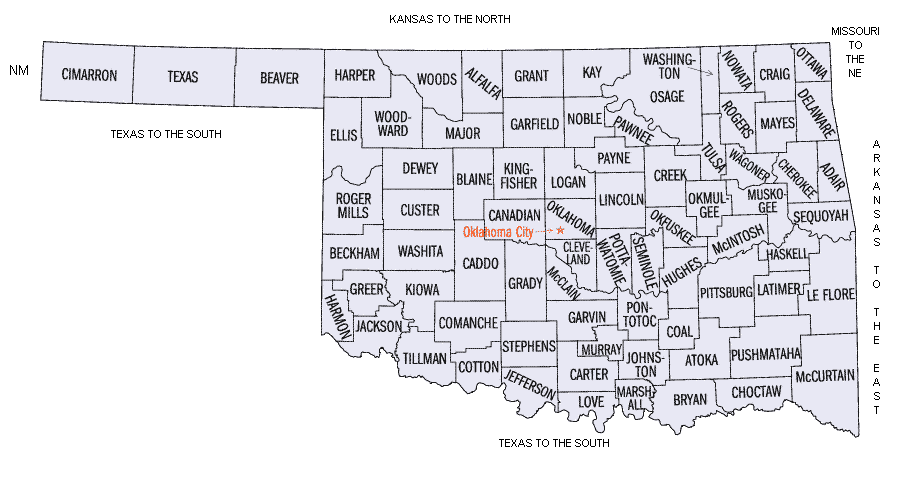
| Oklahoma Map |
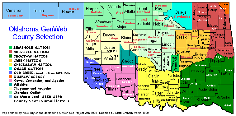
|
| Map of Oklahoma |
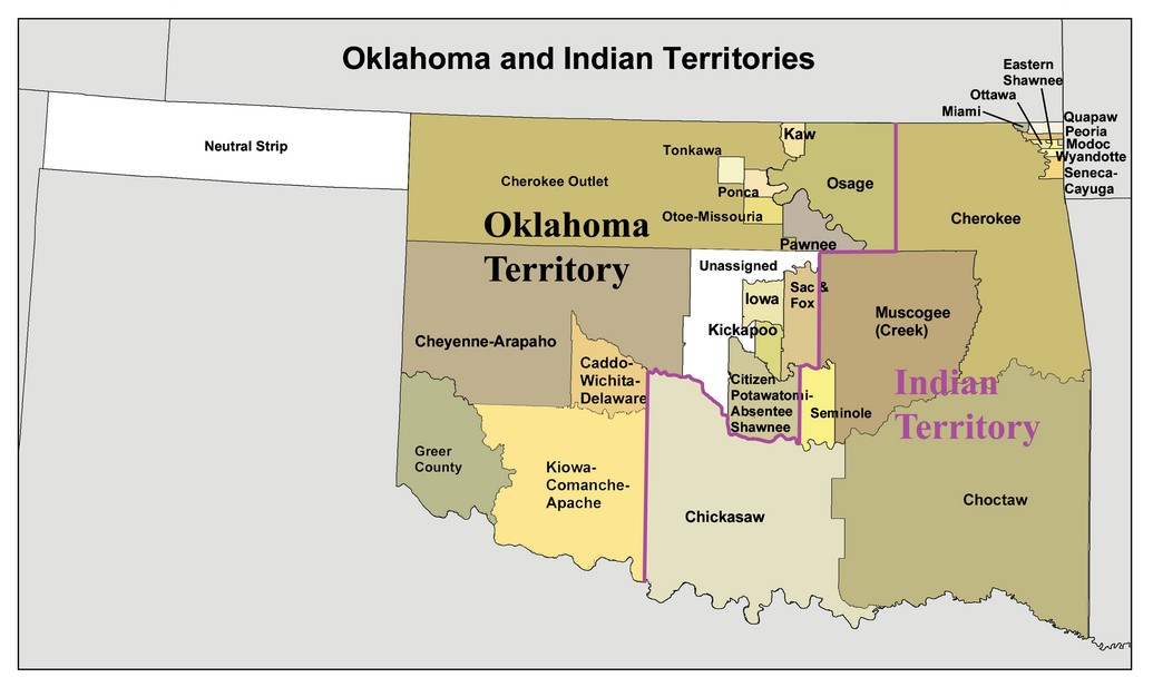
| Oklahoma Native American Indian Map |
|
| (Click to Enlarge) |
Settlement patterns are determined by many factors. Geography, land
policy, sociological circumstances, economics, ethnicity, even religion, readily come to mind. In all of these areas but religion
(Oklahoma is overwhelmingly composed of "Bible Belt" churches), Oklahoma is a border region, neither North nor South, East
nor West, neither all humid nor all arid, but rather like an old-fashioned quilt, made of many pieces, some complementary
and some contrasting.
Geographically, the state is bisected roughly into east and west halves by
the 98th meridian. The climate varies from the humid southeast coastal plains with its cypress wetlands and southern pines
to the semi-aridity of the rolling and High Plains short-grass lands of the northwest. Topography ranges from the Ozark Plateau
of the northeast to the gypsum hills and breaks of the Red River and its tributaries in the southwest. Soils vary from the red clay of much of
central and western Oklahoma to the dark, rich bottom lands of the Red River Valley. The differences in the length
of growing seasons and nighttime temperatures between southern and northern areas create ideal conditions for growing cotton
in the south but limiting its expansion into northern Oklahoma.
The topography is broken by several mountain ranges, including the Wichitas
in the southwest, Arbuckles in the south, Ouachitas in the southeast, and Cookson Hills
(the Oklahoma extension of the Ozark Plateau) in the northeast.
Various geographic conditions set the stage for different agricultural economies. The types of crops also depended upon different
cultural groups. Midwesterners sowed wheat in the north, southerners planted cotton in the south, and plainsmen from Texas and western Kansas raised cattle
in the west.
Some ethnic settlement patterns are also found in Oklahoma. In some areas ethnic groups clustered around mineral wealth. The coal fields opened
by J. J. McAlester near the city bearing his name attracted European ethnic groups, including the Welsh, Irish, Poles, Russians,
Italians, French, and Lithuanians, making McAlester and its environs the most cosmopolitan part of Oklahoma. Later this region
would become the state's bastion of organized labor. Other ethnic groups created their own towns and farming communities.
German Mennonites from Russia, carrying small sacks of Crimean hard wheat,
created farming communities such as Corn, Colony, and Bessie in western Oklahoma.
Czechs from the Midwest founded Prague, Yukon,
and Mishak. Several solidly African American towns, including Boley,
Red Bird, Rentiesville, Taft, and Langston, were created by freedmen of the southeastern Indian nations or by later arrivals
from the South searching for economic opportunities.
The first Oklahomans, the American Indians,
were as varied in their culture and economies as the later settlers. Wichitas
lived as sedentary farmers and hunter-gatherers in grass houses along the watercourses of the central and southern areas.
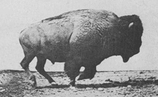
Comanches and Plains Apaches roamed the west, following the bison herds of the Great Plains.
The Quapaws inhabited the northeast as farmers and hunter-gatherers. The later arrivals in the northeast, the Osage, farmed,
but their hunting parties made annual bison hunts on the plains to the west. They also conducted raids on Wichita villages.
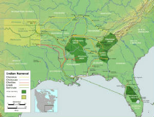
During the first half of the nineteenth century the Indian policy of the federal
government was responsible for uprooting the major American Indian nations of the southeastern United States, many
of whom had already adapted much of the Euroamericans' material culture and farming methods, and conducting them through their
"Trail of Tears" to present day eastern Oklahoma. To accommodate the new
arrivals, the Wichita, Osage, and Quapaw were then confined
by treaty to smaller reservations. Between 1820 and 1837 the Cherokee, Choctaw, Creek, Chickasaw, and Seminole nations (Five Civilized Tribes) arrived with almost nothing except their horses and mules and a scattering of implements, wagons, and household goods. Choctaws
and Chickasaws brought their cotton culture and their African American slaves to open up fresh cotton plantations in the bottom
lands and uplands of the south. The Cherokees settled in the mountains and valleys of the east, while the Creeks were granted
the rolling lands drained by the Canadian River. All of them raised maize, squash, and other
vegetables, as well as livestock, while supplementing their diets with venison, fish, wild fowl, and pecans from the numerous
groves in the bottom lands. The Chickasaws were already known as exceptional horse breeders. By the outbreak of the Civil
War the Five Civilized Tribes, as they came to be called, had created
thriving economies, constitutional governments, and a cultured elite, many of whom were educated in academies and colleges
in the northeastern United States.
The Civil War brought havoc to the Five Tribes and created an excuse
for the federal government to take away much of their lands through treaties for the purpose of moving other Indian peoples
in neighboring states to the emerging "Indian Territory." (See Five Civilized Tribes and the American Civil War.) The aftermath of the war also created conditions in which non-Indians would begin their systematic settlement of Oklahoma and the concurrent destruction of the reservations through
the privatization of tribal lands.
The Euroamerican settlement of Oklahoma
was comparable to earlier westward movement patterns in several ways but was also a unique variation of that movement. As
with earlier American frontier history, non-Indian settlers moved onto former Indian lands obtained by the U.S. government from American Indian tribal leaders through
the "twin Cs," coercion and cajoling. Living in rude shelters, pioneer farmers and their families braved the vicissitudes
of nature and the marketplace to create farms from prairie sod. Towns sprang up along railroad lines, giving rise to small
businesses and small-town society. Grassroots local governments and school boards emerged from primitive election processes.
And, as usual, the needs and wishes of Native peoples were ignored. In fact, the settlement of Oklahoma amounted to an invasion of Indian lands. In other words, the movement was a microcosm
of the American frontier experience encapsulated into only a few years, little more than a decade.
| Map of present-day Oklahoma |
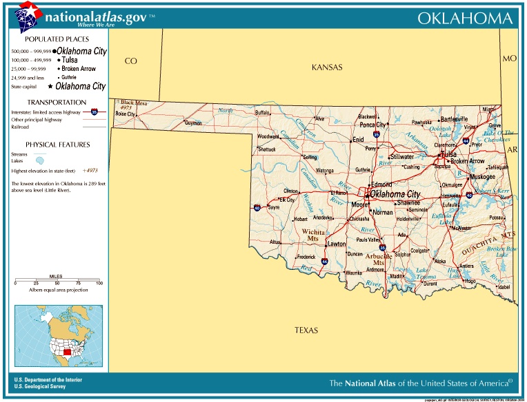
|
| Oklahoma Map |
But the settlement of Oklahoma was also a singular historical experience. Prior
to the first land opening, which came in 1889, the common pattern in westward expansion was for Congress to create first a
relatively large territory by legislative act and to cut it into smaller segments as settlement progressed toward the west.
When the large territory was created, the first settlers were already living in a sparsely inhabited area on its eastern fringe.
As the population grew and spread still further westward, new territories were cut from the original. With the passage of
time, the original territory was finally reduced to several territories that, in turn, entered the Union
as states. Thus the Northwest Territory, created in 1787, was cut into Ohio, Indiana,
Illinois, Wisconsin, and Michigan,
while the Southwest Territory became Kentucky and Tennessee. Utah Territory became Utah,
Nevada, and Colorado. The
Dakotas were cut from Nebraska Territory.
New Mexico Territory was split into Arizona and New Mexico.
By contrast, Oklahoma
began small and expanded into the present day state. Oklahoma Territory was originally known as the Unassigned Lands, and
at the time of the Land Run of 1889 it was officially titled the Oklahoma District and popularly called the "Oklahoma Lands,"
an area of about two million acres. It consisted of the six counties of present central Oklahoma:
Oklahoma, Logan, Cleveland,
Kingfisher, Canadian, and Payne. Over the following eighteen years Oklahoma
added parcel after parcel of land to finally emerge in 1907 as a state. When Oklahoma Territory was created by the Oklahoma
Organic Act of May 2, 1890, the Public Land Strip, or No Man's Land (the Panhandle), was tacked on to become Beaver County
(later divided into three counties). That act also carried a provision that assured the periodic expansion pattern. Adjoining
Indian reservation lands were to be added to the territory if and when the reservations were dissolved through the process
of allotting the lands to individual tribal members under the provisions of the General Allotment (Dawes) Act of 1887.
In 1891 the small Indian reservations on the eastern border, the Sac
and Fox, Potawatomi, Iowa, and Shawnee,
were broken up through allotment. Each man, woman, and child of the tribe received 160 acres of land. Any so-called "surplus"
land remaining was purchased from those tribes and put on the block for sale to settlers who, as in the first opening, became
involved in a horse race for land. Unlike the first race, they were required to buy the land at $1.25 per acre after filing
on it. Two more counties, Lincoln and Pottawatomie, were added, and portions of three of the original counties, Logan, Cleveland,
and Payne, expanded their borders toward the east.
The pattern of allotment and annexation of surplus lands and disposal
by land runs continued through 1895. The sparsely populated Cheyenne-Arapaho Reservation on the western border followed suit
in 1892 with some 3.5 million acres opened. The Cherokee Outlet, owned by the Cherokee Nation and containing reservations
of the Tonkawa and Pawnee along its eastern edge, was opened in 1893 by the largest and the most publicized of all land runs.
Six million acres, or forty thousand claims, were opened to the estimated one hundred thousand who made the run. The small
Tonkawa and Pawnee reservations lying within the boundaries of the Cherokee Outlet had already been broken up by allotment
without surplus lands in 1891 and 1892, respectively. Like the Outlet, they were also tacked onto the expanding territory.
The Kickapoo lands in 1895 were the last to be opened by run.
The Kiowa-Comanche-Apache and Wichita-Caddo reservations were allotted
in 1901 and the surplus disposed of by lottery, the last "surplus" to be available to non-Indian settlers. When the Comanche
Nation sold the Big Pasture in 1906, it was by auction. After the Otoe, Ponca, Missouri,
and Kaw (Kansa) reservations were dissolved in 1905, the lands were added to the territory. Although the Osage Reservation
had been tacked onto the territory in 1893 for jurisdictional purposes, the Osage Nation retained its reservation status until
allotment in 1906. Even then, that nation wisely decided to reserve its mineral rights, all of present day Osage County, for the benefit of the tribe
as a whole.
One part of the territory, "Old
Greer County," was added by
judicial decree. The area bounded by the North Fork of the Red River, the Red River, and the 100th meridian had long been
claimed by Texas, which alleged that the North Fork, not the Prairie Dog Town Fork, was the true source of the Red River.
In the case of United States v. Texas (1896) the U.S. Supreme Court declared that the former rather than the latter
was the true source and attached what would become Greer County
to Oklahoma.
| Oklahoma Map of Counties |
|
| (Oklahoma County Map) |
This piecemeal, crazy-quilt method of evolving a territory initially
through horse races created some problems that took years to solve. First, there was the problem of conflicting claims over
land. The only topographically flat part of Oklahoma is the High Plains of the Panhandle. Most of
the western half of the state consists of rolling plains with timbered bottom lands. Some participants staked their claims
only to discover another claimant on the same 160-acre claim but on the other side of a hill or across the creek beyond woods
that served as a blind between the settlers. Other contests resulted from the claims of "sooners," those who entered the lands
illegally prior to the official openings. Government officials after the run of 1889 tried to prevent this practice in the
Cherokee Outlet Opening by requiring participants to register at booths along the boundary only a few days prior to the legal
opening. Some contests led to violence, while quarreling after staking the claim, or later. William L. Couch, a leader of
the Boomer Movement, died of a gunshot wound inflicted by a rival contestant. Ira N. Terrill, a member of the first territorial
legislature, shot and killed George M. Embrey over a land contest in Stillwater.
The problem finally goaded the Department of the Interior into appointing William F. Harn and John W. Scothorn in 1891 as
special agents to investigate and indict sooners for the crime of perjury.
A second problem was that no townsites were laid out prior to the Land
Run of 1889. The Atchison, Topeka & Santa
Fe Railway had erected a depot at each ten-mile interval when constructing tracks across the Unassigned Lands, but no legal townsites designations
accompanied the depots. The most valuable commercial depot sites were those at Guthrie and Oklahoma City--Guthrie
because it was the presumed but yet-to-be-named capital and Oklahoma City
because it lay astride a natural route for a future east-west railroad line. The run of 1889 was the scene not only of a horse
race for farms, it was also the setting for foot races for commercial and residential "lots," which did not yet exist. At
the start of the run at noon, Santa Fe trains, loaded to excess,
with participants even sitting on top of the cars, began moving from the north and south boundaries at about ten miles per
hour, the assumed speed of an average horse. The trains from the south stopped at the Oklahoma
City station, while their counterparts halted at Guthrie. In both cases, passengers began jumping from
the cars even before a full stop. In a wild melee they ran across the countryside, found a desirable piece of land, and stabbed
the earth with a claim-marking wooden spike. When surveys were then conducted by townsite companies or newly formed town governments,
lot contests became the coin of the realm. In some cases, the choicest lots were tied up in administrative and judiciary cases
for several years before a clear title emerged. Winfield Scott did not get title to the prize corner of Oklahoma Avenue and Second Street
until 1892. When his building was completed in 1893, he named it the Victor Block because, using a well-worn phrase, he said,
"to the victor belong the spoils." In the future, however, the county seats would be laid out by government surveyors prior
to the openings.
Settlement patterns also demarcated political divisions. Midwestern
Republicans flocked to northern Oklahoma. Texans and other
Southern Democrats took up the cotton lands of the bottom lands and uplands north of the Red River.
Midwesterners brought Republican "bloody shirt" politics as far south as Guthrie. Southerners carried Democratic "yellow-dog"
propensities into the territory as far north as Oklahoma City.
The southeastern area of Oklahoma became known as "Little
Dixie."
On the eve of statehood the Oklahoma
Territory occupied the western part of present Oklahoma,
while the older Indian Territory occupied the eastern area. Just prior to statehood the Indian Territory nations, one by one, were pressured into accepting severalty agreements to create allotments
and to destroy their reservations.
When Oklahoma
became the forty-sixth state in 1907, it could have been described as a patchwork quilt of destroyed Indian reservations.
Its citizenry consisted of southern cotton farmers, Midwestern wheat farmers, and western cattlemen, with minorities of American
Indians, African Americans, and ethnic Europeans. The twentieth century brought new urban "settlers" from Asia, the Middle
East, and Latin America, making Oklahoma a state of many
and varied cultural traditions.
| Native Americans and Oklahoma Settlement Map |
|
| Oklahoma Settlement History Map |
(Sources listed at bottom of page.)
Recommended Reading:
The Five Civilized Tribes: Cherokee, Chickasaw, Choctaw, Creek, Seminole
(Civilization of the American Indian) (455 pages: University
of Oklahoma Press). Description:
Fascinating and captivating study of the often referred to Five Civilized Tribes, with each tribe's: evolution, struggles,
Indian removal, treaties, internal and external strife, and outlook...numerous maps and photographs compliment this research.
Continued below...
By focusing on all 'Five Tribes' it also presents a better understanding of how the tribes interrelated
in the Indian Territory (most of present-day Oklahoma). While most authors only focus on "a tribe"
rather than "the tribes," Foreman, by interconnecting the tribes, conveys a more comprehensive understanding of the Five Nations.
Recommended
Viewing: The Trail of Tears: Cherokee Legacy (2006), Starring: James Earl Jones and Wes Studi; Director: Chip Richie, Steven R. Heape.
Description: The Trail Of Tears: Cherokee Legacy is an engaging two
hour documentary exploring one of America's darkest periods in which President Andrew Jackson's Indian Removal Act of 1830 consequently
transported Native Americans of the Cherokee Nation to the bleak and unsupportive Oklahoma
Territory in the year 1838. Deftly presented by the talents of Wes Studi
(The Last of the Mohicans, Dances With Wolves, Bury My Heart at Wounded Knee, Crazy Horse, 500 Nations, Comanche Moon), James
Earl Jones, and James Garner, The Trail Of Tears: Cherokee Legacy also includes narrations of famed celebrities Crystal Gayle,
Johnt Buttrum, Governor Douglas Wilder, and Steven R. Heape. Continued below...
Includes numerous
Cherokee Nation members which add authenticity to the production… A welcome DVD addition to personal, school, and community
library Native American history collections. The Trail Of Tears: Cherokee Legacy is strongly recommended for its informative
and tactful presentation of such a tragic and controversial historical occurrence in 19th century American history.
Recommended
Reading: The Cherokee Nation: A History. Description:
Conley's book, "The Cherokee Nation: A History"
is an eminently readable, concise but thoughtful account of the Cherokee people from prehistoric times to the present day.
The book is formatted in such a way as to make it an ideal text for high school and college classes. At the end of each chapter
is a source list and suggestions for further reading. Also at the end of each chapter is an unusual but helpful feature- a
glossary of key terms. The book contains interesting maps, photographs and drawings, along with a list of chiefs for the various
factions of the Cherokee tribe and nation. Continued
below...
In addition
to being easily understood, a principal strength of the book is that the author questions some traditional beliefs and sources
about the Cherokee past without appearing to be a revisionist or an individual with an agenda in his writing. One such example
is when Conley tells the story of Alexander Cuming, an Englishman who took seven Cherokee men with him to England
in 1730. One of the Cherokee, Oukanekah, is recorded as having said to the King of England: "We look upon the Great King George
as the Sun, and as our Father, and upon ourselves as his children. For though we are red, and you are white our hands and
hearts are joined together..." Conley wonders if Oukanekah actually said those words and points out that the only version
we have of this story is the English version. There is nothing to indicate if Oukanekah spoke in English or Cherokee, or if
his words were recorded at the time they were spoken or were written down later. Conley also points out that in Cherokee culture,
the Sun was considered female, so it is curious that King George would be looked upon as the Sun. The "redness" of Native
American skin was a European perception. The Cherokee would have described themselves as brown. But Conley does not overly
dwell on these things. He continues to tell the story using the sources available. The skill of Conley in communicating his
ideas never diminishes. This book is highly recommended as a good place to start the study of Cherokee history. It serves
as excellent reference material and belongs in the library of anyone serious about the study of Native Americans.
Recommended
Reading: Trail of Tears: The Rise and Fall of the Cherokee
Nation. Description: One of the many ironies of U.S. government policy toward Indians in the early 1800s is that it persisted in
removing to the West those who had most successfully adapted to European values. As whites encroached on Cherokee land, many
Native leaders responded by educating their children, learning English, and developing plantations. Such a leader was Ridge,
who had fought with Andrew Jackson against the British. Continued below...
As he and other
Cherokee leaders grappled with the issue of moving, the land-hungry Georgia legislators, with the aid of Jackson, succeeded
in ousting the Cherokee from their land, forcing them to make the arduous journey West on the infamous "Trail of Tears." ...A
treasured addition for the individual remotely interested in American Indian history as well as general American
history.
Recommended
Reading: Civil War in the Indian Territory, by Steve Cottrell (Author), Andy Thomas (Illustrator). Review:
From its beginning with the bloody Battle of Wilson's Creek on August 10, 1861, to its end in surrender on June 23, 1865,
the Civil War in the Indian Territory proved to be a test of valor and endurance for both
sides. Author Steve Cottrell outlines the events that led up to the involvement of the Indian Territory
in the war, the role of the Native Americans who took part in the war, and the effect this participation had on the war and
this region in particular. As in the rest of the country, neighbor was pitted against neighbor, with members of the same tribes
often fighting against each other. Cottrell describes in detail the guerrilla warfare, the surprise attacks, the all-out battles
that spilled blood on the now peaceful state of Oklahoma. Continued below...
In addition, he introduces
the reader to the interesting and often colorful leaders of the military North and South, including the only American Indian
to attain a general's rank in the war, Gen. Stand Watie (member of the Cherokee Nation). With outstanding illustrations by
Andy Thomas, this story is a tribute to those who fought and a revealing portrait of the important role they played in this
era of our country's history.Meet The Author: A resident of Carthage, Missouri, Steve Cottrell is a descendant of a
Sixth Kansas Cavalry member who served in the Indian Territory during the Civil War. A graduate
of Missouri Southern State College in Joplin, Cottrell has
participated in several battle reenactments including the Academy Award winning motion picture, "Glory". Active in Civil War
battlefield preservation and historical monument projects and contributor of a number of Civil War relics to regional museums,
Cottrell recently co-authored Civil War in the Ozarks, also by Pelican. It is now in its second printing.
Recommended
Reading: The
Blue, the Gray, and the Red: Indian Campaigns of the Civil War (Hardcover: 288 pages). Description:
Inexperienced Union and Confederate soldiers in the West waged numerous bloody campaigns
against the Indians during the Civil War. Fighting with a distinct geographical advantage, many tribes terrorized the territory
from the Plains to the Pacific, as American pioneers moved west in greater numbers. These noteworthy--and notorious--Indian
campaigns featured a fascinating cast of colorful characters, and were set against the wild, desolate, and untamed territories
of the western United States. This is
the first book to explore Indian conflicts that took place during the Civil War and documents both Union
and Confederate encounters with hostile Indians blocking western expansion. Continued below...
From
Publishers Weekly: Beginning with the flight
of the Creeks into Union territory pursued by Confederate forces (including many of Stand Watie's Cherokees), this popular
history recounts grim, bloody, lesser-known events of the Civil War. Hatch (Clashes
of the Cavalry) also describes the most incredible incidents.... Kit Carson, who fought Apaches and
Navajos under the iron-fisted Colonel Carleton, arranged the Long Walk of the Navajos that made him infamous in Navajo history
to this day. The North's "Captain" Woolsey, a volunteer soldier, became a brutal raider of the Apaches. General Sibley, a
northerner and first Governor of Minnesota, oversaw the response to the Sioux Uprising of 1862 that
left several hundred dead. The slaughter of Black Kettle's Cheyennes at Sand Creek in
1864 by Colorado volunteers under Colonel Chivington,
a militant abolitionist whose views on Indians were a great deal less charitable, “forms a devastating chapter.”
Hatch, a veteran of several books on the Indian Wars that focus on George Armstrong Custer, has added to this clear and even-handed
account a scholarly apparatus that adds considerably to its value.
BIBLIOGRAPHY: Brad Agnew, "Voices from the Land Run of 1889," The Chronicles
of Oklahoma 67 (Spring 1989). Gene Aldrich, Black Heritage of Oklahoma (Edmond, Okla.: Thompson Book and Supply Co., 1973).
W. David Baird and Danney Goble, The Story of Oklahoma (Norman: University of Oklahoma Press, 1994). Karel E. Bicha, The Czechs
in Oklahoma (Norman: University of Oklahoma Press, 1980). Berlin B. Chapman, Oklahoma City, from Public Land to Private Property
(Oklahoma City: Oklahoma Historical Society, 1960). Berlin B. Chapman, The Founding of Stillwater: A Case Study in Oklahoma
History (Oklahoma City: Times Journal Publishing Company, 1948). Arrell M. Gibson, Oklahoma: A History of Five Centuries (2nd
ed.; Norman: University of Oklahoma Press, 1981). Arrell M. Gibson, "The Centennial Legacy of the General Allotment Act,"
The Chronicles of Oklahoma 65 (Fall 1987). Roy Gittinger, The Formation of the State of Oklahoma, 1803-1906 (Norman: University
of Oklahoma Press, 1939). Donald E. Green, "The Oklahoma Land Run of 1889: A Centennial Re-Interpretation," in The Chronicles
of Oklahoma 67 (Summer 1989). Donald E. Green, "To the Victor Go the Spoils," Guthrie Illustrated 1 (Fall 1983). Donald E.
Green, "Winfield S. Smith and the Urban Land Run of 1889," Persimmon Hill (Spring 1989). Marvin E. Kroeker,"'Die Stillen im
Lande': Mennonites in the Oklahoma Land Rushes," The Chronicles of Oklahoma 67 (Spring 1989). Howard R. Lamar, "The Creation
of Oklahoma: New Meanings for the Oklahoma Land Run," in The Culture of Oklahoma, ed. Howard F. Stein and Robert F. Hill (Norman:
University of Oklahoma Press, 1993). Gary L. Thompson, "Green on Red: Oklahoma Landscapes," in The Culture of Oklahoma, ed.
Howard F. Stein and Robert F. Hill (Norman: University of Oklahoma Press, 1993). Alvin O. Turner, "Order and Disorder: The
Opening of the Cherokee Outlet," The Chronicles of Oklahoma 71 (Summer 1993). Jerald C. Walker, "The Difficulty of Celebrating
an Invasion," in "An Oklahoma I Had Never Seen Before": Alternative Views of Oklahoma History, ed. Davis C. Joyce (Norman:
University of Oklahoma Press, 1994).
Donald E. Green
© Oklahoma Historical Society
|

