|
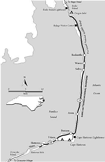
Cape Hatteras and Outer Banks North Carolina Map
Cape Hatteras Scenic Route Map
| North Carolina: Outer Banks: Cape Hatteras Map |
|
| Courtesy weather.com |
General description:
A 48-mile drive past the
seemingly endless beaches and dunes of Cape Hatteras National Seashore, with a visit to a wildlife refuge and what is probably
the best-known lighthouse in America.
Special attractions:
Beaches, the Cape Hatteras lighthouse,
boating, fishing, surfing, swimming, hiking, wildlife.
Location:
Upper North Carolina coast. The drive lies on the
Outer Banks and starts at the bridge that connects Bodie Island to Pea Island, a short distance south of Nags Head.
Drive route number:
NC 12
Travel season:
All year. Summer is hot, but ideal for beach
activities. Spring and fall are less crowded with cooler temperatures. Winter can be chilly and stormy.
Camping:
Cape Hatteras National Seashore manages public campgrounds
at Frisco, by the Cape Hatteras Lighthouse, and just north of the drive by Oregon Inlet at the south end of Bodie Island.
Services:
Most services are available at Avon, Salvo, Waves,
Rodanthe, and Frisco. They are most plentiful in Buxton and Hatteras. Lodging can be tight in summer, especially on weekends,
even with a large supply of motel rooms, rental houses, and cottages.
The drive: This travels the length of Pea and Hatteras
islands and includes much of Cape Hatteras National Seashore. Unlike the stretch of the Outer Banks to the north, most of
this drive passes through undeveloped country. It offers extensive opportunities for swimming, fishing, beachcombing, sunbathing,
hiking, and wildlife observation. One of the most noteworthy landmarks of the Atlantic coast, the Cape Hatteras Lighthouse,
looms over the southern part of this drive.
The drive starts at the highest point of Bonner Bridge, linking Bodie Island
to Pea Island. This long bridge offers great views of the Atlantic to the east and the Pamlico Sound to the west. It snakes
its way across Oregon Inlet, the ocean channel that separates Pea and Bodie islands. These two islands, as all the other islands
of the Outer Banks, are barrier islands.
Barrier islands are little more than low-lying, sandy strips of land that
exist at the mercy of the ocean and its violent storms. The islands are formed by wind and wave and are constantly changed
by the same forces. The North Carolina barrier islands are important because they protect the sounds and the mainland from
the full brunt of Atlantic Ocean storms. However, these storms constantly rework the islands. Pea Island and Hatteras Island
were once separate, but the channel that separated them sanded closed many years ago. Oregon Inlet, on the other hand, was
opened by a hurricane in 1846. It took its name from the ship Oregon, the first to pass through it. Since then, the inlet
has moved south almost three miles.
Until fairly recently, the people of Hatteras Island lived in relative isolation.
Ferry service operated by private entities began in 1924. Eventually the state took over its operation. In 1963, the Bonner
Bridge opened. The island's isolation could return at any time, since the bridge is nearing the end of its useful life. Corrosive
salt water and the constant pounding of storms take a toll on any structure. Replacement is problematic because of the great
expense, the constant migration of the inlet, and environmental concerns.
At the south end of the bridge, on Pea Island, there is a parking area on
the left side of the road used by fishermen and beach-goers. To help stabilize Oregon Inlet for navigation, a controversial
jetty was built here in the early 1990s. Time will tell whether it helps. A short side road a short distance south along NC
12 leads to the abandoned Oregon Inlet Coast Guard Station.
Continue to follow NC 12 south. To your left, tall dunes rise between the
beach and the road. These dunes were built and planted with vegetation by the Civilian Conservation Corps during the 1930s
to help stabilize the island. As you would expect with the ocean so near, storms regularly break through the dunes and send
waves washing across the drive route. Additionally, wind constantly blows sand from the dunes across the road. Repairing such
damage makes this an expensive road to maintain. It's tempting to pull off onto the sandy roadside so that you can hop over
the dunes to the beach, but wait until you get to one of the many paved parking areas along the highway. The sand at the roadside
is soft and pulling off here is an invitation to getting stuck.
When you get to the Pea Island National Wildlife Refuge Visitor Center, be
sure to stop. It offers refuge exhibits and information; it also sells items such as bird books and mosquito repellent. Consisting
of 5,915 acres of the island and 25,700 acres of Pamlico Sound, the refuge was created in 1938. At one time, the majority
of the western hemisphere's greater snow goose population wintered here. The geese foraged in the dunes for looking for the
nutritious "dune peas" that gave the island its name.
Although the refuge was established primarily as a sanctuary for geese and
other waterfowl, it lies on the Atlantic Flyway and is a haven for many other kinds of birds. More than 300 species have been
reported here. The beaches of the refuge are crucial nesting sites of endangered sea turtles, including the loggerhead. The
nest temperature of the loggerhead turtle determines its sex. Because of the sand's coolness here at the northern edge of
their nesting range, most young hatched here are male. These nests may produce many of the entire turtle population's males.
Be sure to take the easy hiking trail that starts at the refuge visitor center.
It starts as a boardwalk over a small freshwater pond. Look for turtles sunning on logs here. It then follows a dike out across
large freshwater ponds to several wooden observation platforms. If you feel energetic, you can loop all the way around North
Pond from the end of the dike trail, returning to your car by walking the last section along NC 12. Be sure to take insect
repellent in summer.
About three miles farther down the drive, you will pass the New Inlet boat
launch, on the right. Until storms closed the inlet in 1945, it separated Pea and Hatteras islands. Continue on the drive
by following NC 12 south to the boundary of the refuge at the village of Rodanthe. This town is the first significant development
on the drive. Unlike the mega-tourist towns on the northern part of the Outer Banks, the communities of Rodanthe, Waves, Salvo,
and Avon are much more modest. There isn't much neon or plastic in these towns, and national restaurant and motel chains are
almost nonexistent. Cape Hatteras National Seashore starts here, on the beach side of town. The National Park Service has
a fishing pier concession here.
Before you leave Rodanthe, be sure to visit the Chicamacomico U.S. Life Saving
Service Station. Dating to 1874, this station was one of the first built on the Outer Banks. Crews posted at these stations
saved countless lives when ships wrecked on the treacherous shores of the islands. Since Europeans began sailing these shores
in the 1500s, at least 600 ships and maybe more than 2,000 have wrecked along the banks. The area has became known as the
Graveyard of the Atlantic. Cape Hatteras's reputation for wrecks was thus established early in American history; the graveyard
nickname was coined by Alexander Hamilton after a traumatic passage around the cape as a boy.
As engines replaced sails, shipwrecks declined on the Outer Banks. World War
II temporarily halted the decline. German U-boats took up stations off the North Carolina coast in early 1942, sinking so
many ships that the area became known as Torpedo Junction. The life savers were kept busy until an effective defense was mounted.
Today, sunken U-boats and other ships are popular destinations of recreational divers. After the war, improved navigation
systems and weather forecasting again decreased the number of wrecks and the need for the life saving stations declined. The
Chicamacomico station was closed in 1954, but has been restored as a museum in recent years.
The towns of Rodanthe, Waves, and Salvo run together, forming a relatively
continuous stretch of development about five miles long. Beyond Salvo, the drove enters an 11-mile stretch of undeveloped
national seashore. Dunes, marshes, and scrub forests of pine and other trees line the highway. The road then enters Avon,
a growing beach resort town. There is another ocean fishing pier here. From Avon, at the widest part of Pamlico Sound, the
30-mile-wide sound appears as large as a sea. At no other place in the United States are barrier islands so far offshore.
After Avon, the highway reenters the undeveloped land of the national seashore.
The road passes a popular windsurfing area on the sound a little south of town. Hatteras Island becomes very narrow here and
highly vulnerable to ocean storms. Regular repairs have to be performed to maintain the protective beachside dunes and the
highway. In 1962 a ferocious storm cut through the island completely along here, requiring a massive repair effort. The road
soon enters Buxton, site of the Cape Hatteras Lighthouse. A marked side road leads a short distance to this famous landmark.
The 200-foot brick tower is the tallest lighthouse in the United States.
Because Cape Hatteras protrudes far out into the Atlantic, it creates a navigation
hazard. However, that is only the start of the area's shipping problems. A shallow, barely submerged finger of sand called
Diamond Shoals juts more than ten miles out into the ocean from the cape, just begging for ships to run aground. Sailors have
long used ocean currents that flow offshore of the Outer Banks to speed their travel. A short distance offshore, the warm
Gulf Stream flows north at four knots and veers eastward. Northbound ships followed this current to shorten their trips. Between
the Gulf Stream and the coast, a colder counter-current, the Virginia Coastal Drift, flows south. Not surprisingly, southbound
ships followed this current south. Unfortunately, the Gulf Stream pinches this current into a very narrow channel at Cape
Hatteras, forcing ships to sail very close to Diamond Shoals. Storms or slight errors in navigation set the stage for many
shipwrecks here over the years.
Pushed in part by Alexander Hamilton, Congress authorized a lighthouse at
the cape in 1794. However, the first tower was not completed until 1803. The 90-foot tower was small and had a weak light;
it suffered frequent outages during storms, just when it was most needed. Ship captains complained vociferously. "As usual
no light is to be seen from the lighthouse," one stated in 1837 after rounding the cape. In the 1850s the tower was raised
to more than 150 feet and an efficient Fresnel lens was installed to brighten the light. Unfortunately, this new, much-improved
tower suffered serious damage during the Civil War.
The taller brick tower that stands here today was begun in 1869 and completed
the following year. Its distinctive spiral striping was added to serve as a useful daytime navigation aid--in other words,
to help sailors distinguish this lighthouse from others along the Outer Banks.
In warm months, the lighthouse tower is open to visitors willing to climb
the 257 steps to its top. It offers a panoramic view of Cape Hatteras, the ocean, and the sound. The former keepers' quarters
house a visitor center with exhibits on the lighthouse, shipwrecks, and nearby life saving stations. Another building houses
a good bookstore carrying many titles on lighthouses, the Outer Banks, and related subjects. The beach near the lighthouse
is one of the Atlantic coast's surfing hotspots.
As is obvious to visitors, the lighthouse lies very close to the breaking
waves of the Atlantic. When it was completed, it was 1,500 feet from the ocean. Since that time, currents and storms have
eroded the cape. By 1935, waves washed around the base of the tower and it was abandoned. However, changes in the currents
and beach erosion control work by the CCC temporarily reversed the erosion in the late 1930s and the lighthouse was recommissioned
in 1950. Unfortunately, erosion patterns have changed again and the sea is again encroaching on the tower; it's little more
than 100 feet away now. Erosion control efforts have been made, but the ocean is relentless.
To save the lighthouse, the National Park Service has proposed a controversial
plan to move it as much as a half mile inland. Not surprisingly, moving a 200-foot-tall tower built of 1,250,000 bricks is
an extremely expensive undertaking--it would cost an estimated $12 million. Congress authorized $2 million in late 1997 to
draft a plan to move it. Funding for the rest has yet to be authorized. One hopes that the move can be completed before a
hurricane claims one of the finest lighthouses in the United States.
Before you return to the highway, follow the park road toward the campground
to the Buxton Woods Nature Trail, located at a roadside picnic area. This 0.75-mile long trail loops through lush forest,
part of Buxton (Cape Hatteras) Woods. The island at the cape is wide enough to allow the largest tract of maritime forest
in North Carolina to survive. A combination of dunes that protect the forest from salt spray, a great enough distance from
the ocean, and a freshwater aquifer allow the forest to exist. However, it is constantly stressed by wind and salt and doesn't
really thrive. Many dead pines are evident on the island. A recent storm weakened and killed many; insects took advantage
and finished off the weakened trees. Although more than half of the forest is owned by government entities, the rest is threatened
by development.
The easy nature trail takes you through a thick forest of loblolly pines,
live oaks, dogwoods, American hornbeam, yaupon, bayberry, and even the tropical-looking palmetto to the shores of a shallow
marsh. In summer, take mosquito repellent and keep an eye open for snakes as you hike the trail.
At the cape, the island and the highway make an abrupt turn southwest. Follow
the road through Buxton, which blends in with the next town on the island, Frisco. There is another ocean fishing pier here
and a National Park Service campground. Beyond Frisco, the island narrows and the forest becomes scrubby. The road reenters
the national seashore for a short distance then enters Hatteras, the largest town on the island. This busy place has plenty
of lodgings, although they can fill up in summer. Beaches, marinas, and sun draw many thousands of people here every year.
Wind your way through the town to the end of the drive at the Hatteras-Ocracoke
Ferry, which crosses Hatteras Inlet. A hurricane blasted Hatteras Inlet open, separating Hatteras and Ocracoke islands. The
Confederate States Army constructed two forts here to guard the inlet in 1861. When the forts fell soon after, they gave the
Union its first victory of the Civil War. Except when storms strike, the inlet is peaceful today. The ferry here began operating
in 1953 as a private ferry service. Today the state runs the busy concession, carrying more than a half-million people across
Hatteras Inlet every year. In summer, the wait for a ferry can be long. If you have time, consider taking the free, 40-minute
ferry ride to Ocracoke Island.
For more information: Cape Hatteras National Seashore (National
Park Service), Pea Island National Wildlife Refuge, Outer Banks Chamber of Commerce, Dare County Tourist Bureau. See Appendix
for addresses and phone numbers.
Credit: weather.com
(visit weather.com for all your weather and travel needs); Adapted from the FalconGuide Scenic Driving North Carolina
by Laurence Parent.
Recommended Reading: Scenic Driving North Carolina, 2nd,
by Laurence Parent (Scenic Driving Series). Description:
Pack up the car and enjoy thirty drives through some of the most spectacular scenery in the Tar Heel State. This indispensable
highway companion maps out trips for exploring scenic byways and side roads, from the deep forests and breathtaking views
of the Blue Ridge Parkway to the majestic lighthouses and historic villages of the Outer Banks, from the lush rolling country
of the Piedmont to the rugged terrain of the Appalachian Mountains. Continued below…
Inside you'll
find: Itineraries ranging from 10 miles to more than 115 miles in length; Route maps for each drive; Where to find treasures
such as windswept dunes, mountain streams, magnificent fall colors, roaring waterfalls, and local wildlife; Historical information
and suggested side trips; Tips on camping, travel services, and best driving seasons. About the Author: Laurence Parent is
a freelance photographer and writer specializing in landscape, travel, and nature subjects. He has written twenty-one books,
including seven FalconGuides. He resides in Wimberley,
Texas.
Recommended
Reading: North Carolina Atlas & Gazetteer (North Carolina Atlas and Gazetteer). Description:
This is not your ordinary map! This Atlas is filled with comprehensive and detailed maps. It covers all three Regions of North
Carolina: Coastal Plain, Piedmont, and Mountains. It is the first choice for outdoor enthusiasts
– sports, hiking, fishing, rock climbing, skiing, boating, bird watching, tubing, kayaking, hunting, etc. “Beautiful,
detailed and large-format…” (1) Physical land features: topographic contours, water resources, vegetation, etc.
(2) Off-road options: trails, abandoned railroads, ferries. (3) Recreation: Parks, outdoor sports, points of interest. It
is perfect for home and office reference, the casual and business traveler, and every vehicle. Continued below...
Gazetteer information
even includes: campgrounds, attractions, historic sites & museums, recreation areas, trails, freshwater fishing sites
& boat launches, canoe trips or scenic drives. Reviews: “I am a full-time fishing guide in the mountains of North Carolina
and I have found this book to be the absolute best reference material for finding trout streams in our mountains. If you do
any type of outdoors activities you will benefit from this book.” “Instead of purchasing numerous cumbersome North Carolina maps and atlases, I bought the North Carolina Atlas
& Gazetteer and I am very pleased – it is definitive, complete, and all-in-one.” “My wife and I recently
retired and started traveling, as we always dreamed about doing, and the numerous detailed pages in this Atlas saved us time
and money while traveling across the beautiful state of North Carolina…we were able to find those out of the way flea-markets,
historic landmarks, and small town museums. I highly recommend it.”
Recommended Reading: Graveyard of the Atlantic: Shipwrecks of the North Carolina Coast.
Description: This is a factual account, written in the pace of fiction, of hundreds of dramatic losses heroic rescues and
violent adventures at the stormy meeting place of northern and southern winds and waters—the Graveyard of the Atlantic off the Outer Banks of North Carolina. Continued below...
The author describes some of the most climatic sinkings such as the USS Huron, the SS Metropolis, the steam
packet Pulaski. He also chronicles the birth and growth of the US Life Saving Service and some of the most exciting rescues
in history. Overall this is a fine and engrossing book, written by an author intimately connected with his topic.
|