|
North Carolina Mountains and the Civil War
Western North Carolina and American Civil War
History Homepage
Introduction
Western North Carolina, known by many as
WNC, and its involvement during the Civil War was described by a battle-hardened lieutenant colonel who had been raised
across the border in East Tennessee only to live out his postwar years in the mountains of WNC. When asked by the State
of North Carolina to write the official Civil War history for its only legion, Thomas' Legion, the former colonel would also
state his conviction on the subject of what caused the Civil War as well as the common soldier's motive for fighting
in the conflict. In Western North Carolina, "A great majority of the people were poor
and had no interest in slavery, present or prospective. But most of them had little mountain homes and, be it ever so humble, there is no place like home...but when the Federal army occupied
East Tennessee and threatened North Carolina..." Lt. Col. William W. Stringfield, Histories of the Several Regiments and Battalions from North Carolina
in the Great War 1861-'65, Vol., 3, p. 734, while discussing the official history of the Thomas Legion in 1903.
The late colonel was of the prominent Stringfield family of Strawberry Plains, a rural mountain community in East TN.,
but when a bright-eyed girl across the border in the Mountain Region of the Tar Heel State captured
his heart, he collected his belongings and moved across the border to Waynesville, where he would live for the next
fifty-eight years, raise a family, and then be buried.
| Western North Carolina and the Civil War |
|
| Western North Carolina, aka North Carolina Mountains, and Civil War |
Western North Carolina
The three landforms of North Carolina account for its three major geographic
regions known as Coastal Plain Region, Piedmont Region, and Mountain Region. Western North Carolina and East Tennessee co-host the Great Smoky Mountains, which form a portion
of the Blue Ridge Mountains and are a subrange of the Appalachian Mountains.
While the Mountain Region is also known as Western North Carolina, it is smaller
in area than the Piedmont and Coastal Plain, and the elevation in this landform soars to more than one mile high. The Blue
Ridge Mountains separate the Piedmont from the Mountain Region, and other ranges in this rugged terrain include the Bald,
Balsam, Black, Brushy, Great Smoky, Iron, Pisgah, Stone, and Unaka. All of these ranges are part of the larger Appalachian
Mountains, which possibly is the oldest mountains in the United States. Western North Carolina has 43 mountain peaks that
rise to over 6,000 feet and 82 that rise to more than 5,000 feet. Mount Mitchell in the Black Mountain range is 6,684 feet
high, making it the highest point in North Carolina and the highest in the United States east of the Mississippi River. The
Eastern Continental Divide runs east from those flowing west, and rivers on the eastern side of the divide flow east toward
the Atlantic Ocean. Rivers that run on the western side of the divide flow toward the Tennessee and Ohio rivers and into the
Gulf of Mexico.
| Western North Carolina in the Civil War |
|
| Western North Carolina consisted of rural mountain communities in 1860 |
| Western North Carolina and the Civil War |
|
| Western North Carolina consists of the Mountain Region landform. |
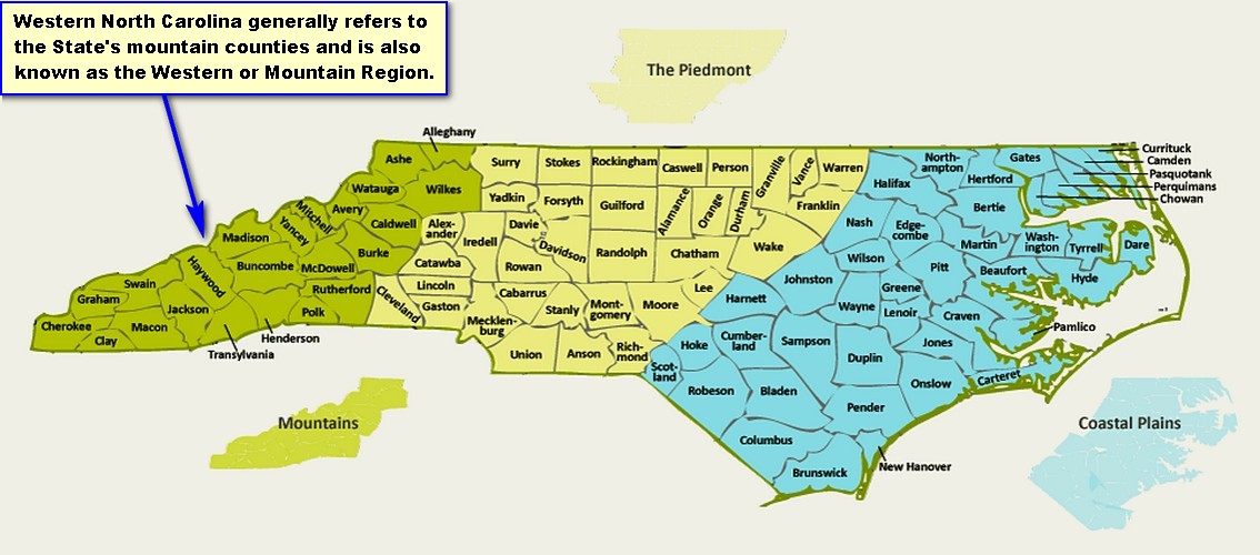
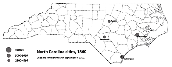
(Left) An 1860 North Carolina map showing population comparison between
selected cities. (Right) The present-day 23 counties of North Carolina that are most commonly associated with Western
North Carolina.
Mountain Region
The Mountain Region is synonymous with Western North Carolina and it remains the least
populated area within the Old North State. In 1860, while slaves comprised 11.3% of Western North Carolina's inhabitants, slaves tallied 33% of the State's entire population. The Coastal Plain Region was home to the majority
of the citizens in 1860, including slaves, due mainly to large plantations along the coast and the area's seaports
operating as a vibrant transportation hub with its shipping and receiving of a variety of goods. While the western portion
of the State was occupied mainly with yeomen farmers, nearly one-half, 45.2%, of North Carolina citizens claimed farmer
as their occupation in 1860.
During the antebellum period, North Carolina was an overwhelmingly rural
state, even by Southern standards. In 1860 only one North Carolina town, the port city of Wilmington, had a population of nearly
10,000. Raleigh, the state capital, had barely more than 5,000 residents, and the largest city in Western North Carolina was
Asheville with a population of 1,100.
Although
county lines have been redrawn and additional counties have been added to the State since the 86 counties were
tallied at the beginning of the Civil War, the mountains remain the geographical region of Western North Carolina.
Why were county lines redrawn and new counties added? County histories vary state by state, but in North Carolina, by restricting
the size of the county, it allowed those traveling on horseback and wagon the opportunity to arrive in the business center, known
as the county seat, in a single day.
| WNC and Shelton Laurel Massacre |
|
| A Civil War Massacre in Western North Carolina |
"The
Cumberland Gap is the Gibraltar of America," General Ulysses S. Grant, January 1864
Asheville
Although Asheville was a small secluded
mountain community nestled in WNC, it remained a contest of wills during
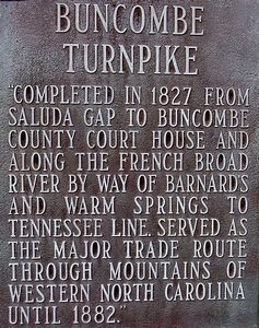
the conflict, and as the county seat it hosted the Buncombe Turnpike, the most traveled route to and from
East Tennessee, as well as an armory and principal training camp during the war.
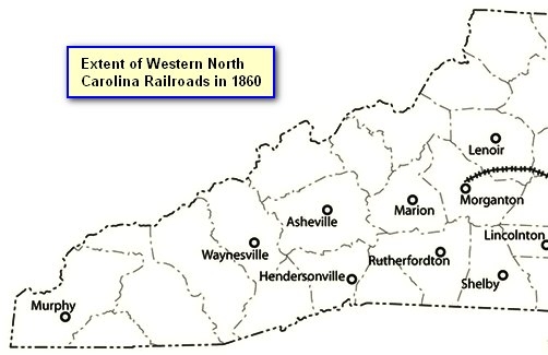
| Western North Carolina Civil War Railroads Map |
|
| Maps showing Extent of Western North Carolina Railroads in 1860 |
Asheville
had a population of 1,100 in 1860 and was the largest city in Western North Carolina, and during the Civil War (1861-1865)
it hosted an armory which manufactured Enfield type rifles until 1863 as well as some training camps and fortifications.
For most of the conflict, while the Tar Heel State's coastal towns and ports had endured frequent Union bombardments
and attacks, Asheville, besides being the object of a few raids, was absent any major Union assault until 1865.
The 1860 U.S. census
shows that Buncombe County had a population 12,654 and 1,933 slaves. The county seat of Asheville
totaled 1,100 citizens and according to the slave schedules enumerated on August 16, 1860, the mountain city listed an
additional 750 slaves. In 1860, slaves comprised 15% of the populace of Buncombe County and 68%
of the total population of Asheville.
By 1860, Asheville dominated the region politically
and economically, and it was a large trading center for the immense variety of goods that were arriving from Europe via ports
of Wilmington and New Bern and from other rich seaport cities of the Deep South such as Charleston and Savannah. Merchants
from Kentucky, Virginia, Georgia, and Tennessee would arrive daily in Asheville to purchase and exchange an abundance
of commodities including livestock and cash crops. By all standards, Asheville had become
the economic center for the region by 1860 and was enjoying the status of a boomtown.
The pristine mountain
community was spared any major battle, but it suffered the privations familiar to many other Southern cities. In the
first week of April 1865 the dynamics of the conflict had changed, however, because Gen. Robert E. Lee, after a nearly
ten month siege at Richmond-Petersburg, had moved the battered Army of Northern Virginia toward Appomattox, causing the Confederate
capital of Richmond to capitulate on April 3, and less than one week later, on April 9, Gen. Lee would surrender
to Lt. Gen. Grant. Emboldened by Richmond's demise, Union commanders were no longer appeased with their harassing raids
against the mountain enclave, but unleashed punishing blows as the curtain was closing for the final act and even moved into
the area and forced the Battle of Asheville.
The war left Asheville financially bereft,
and by 1870, Tennessee, Georgia, and Alabama were connected by rail causing the abandonment of the cumbersome journey along
the Buncombe Turnpike and the rapid decline in commerce at Asheville. While construction continued on the Morganton rail in
1877, it wasn't until 1880 that it linked with Asheville, making a watershed event followed by much celebration. Tourism
would replace commerce and cause Asheville to rapidly became a favorite destination with 30,000 visitors arriving by
rail each summer.
Strategic
Significance
| WNC and the Civil War |
|
| Buncombe Turnpike |
Asheville, the crown jewel of Western North Carolina,
was conveniently situated in the heart of the Mountain Region and it hosted the only major highway with
a direct route from East Tennessee to South Carolina. The strategic value of the city was not vested in its
armory, with a negligible production of rifle-muskets, its few training camps, nor its ability to sustain and prolong
the conflict, but with the city's location. If the Union army occupied the city it would cause the region to be split into
two sections, and it would shorten the distance to Columbia, the capital of South Carolina. Since Federal forces
were already pushing inland from North Carolina's coastal cities, to gain a foothold in the western part of the
Tar Heel State would easily place Raleigh, the host capital, in the clutch of a pincer movement from both the east and west.
For
any Federal command hoping to arrive in the Carolinas by way of Tennessee, the heavily traveled Buncombe Turnpike was the preferred route. Absent railroads
betwixt the Old North and Volunteer states, the rough-planked turnpike was the only direct route from East
Tennessee to the most populated city in the Mountain Region known as Asheville. This 75-mile popular path, which had
hosted from pungent pigs and heavy hogs to Europe's finest smelling perfumes, was part of an early interstate network allowing
goods and livestock to be moved from the grand ports of Wilmington and Charleston to far away destinations in Ohio
and Illinois.
The Buncombe Turnpike traversed from the NC/SC state line near Greenville across the Asheville plateau
along the French Broad River to just north of Warm Springs where it joined the Tennessee Road. Because the Buncombe Turnpike spanned from East Tennessee to the South Carolina border, Western North Carolina was an open highway allowing any sizeable force a direct route into the backcountry of
the rebellion. When the turnpike was completed in late 1827, Asheville would celebrate it first economic boom and some
of its citizens would soon be numbered among the wealthiest in the state. By capturing Knoxville in 1863, the Union army was
able to use the largest city in East Tennessee as a forward operating base and launch incursions into Western North Carolina.
Since there were no railroads in the vicinity,
the Buncombe Turnpike served as the main route for transporting all livestock and necessaries between Western North Carolina and East Tennessee. The mountain enclave was the staging area for forwarding cavalry and infantry to the defense of
the Confederacy's railroads and depots in
East Tennessee. The rails hosted the only tracks available for the quick transport of troops, ammunition, and
provisions to the front and between its two major theaters in the east and west as well as to check any large Union army
moving into the region. The thin gray-clad line spanning the Blue Ridge Mountains was responsible for protecting and defending
the area's vital railroads at all hazards, and Private James Keelan of Thomas' Legion, for instance, found himself alone one night while guarding
a railroad bridge in East Tennessee until a group of bridge burners forced the young private to define the
meaning of fighting "at all hazards." The determined Keelan, refusing to succumb to overwhelming odds, single handedly
fought against several men during the bloody hand-to-hand contest, and though he nearly bled to death during the struggle,
he successfully secured the Strawberry Plains
Bridge. As a result of his selfless and heroic actions while defending the vital bridge, Keelan
was posthumously awarded the Confederate Medal of Honor.
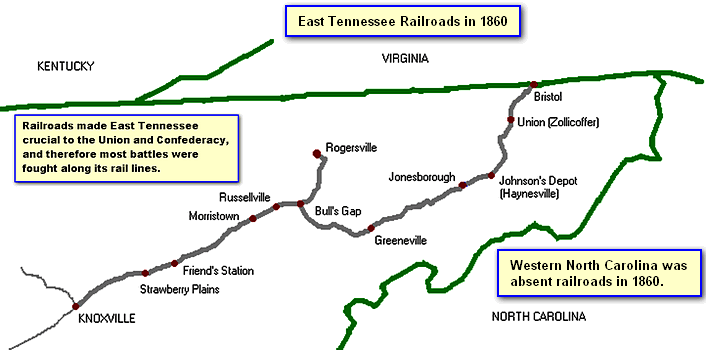
| Western North Carolina Civil War History |
|
| The vital East Tennessee Railroads in 1860 |
During
the peculiar sight of a large Confederate contingent melting before the very presence of Federals marching in the
vicinity, the city of Knoxville would
stand at awe as the Union army would continue its advance unopposed until in arrived and claimed the prized
city of East Tennessee and the railroads it hosted in September of 1863. Although Rebel forces would eventually contest
the city's new ownership cautiously, Knoxville would remain a Union stronghold for the duration of the war. The Confederate
command, however, could not remain at ease nor ignore the constant Union threat that now loomed just over the North
Carolina border and at the center of a state that it deemed critical to its war making capabilities.
The North Carolina units serving in the mountains would concentrate
their depleted resources along the ridges and in defense of the Buncombe Turnpike. On its shared border with Virginia,
the region would host a reserve force that could be called out at a moments notice for the defense of the South's major
producer of salt in nearby southwestern Virginia. Neighboring East Tennessee was home to the
only railroad in the area, making it critical to the lifeline of the Confederacy.
Western North Carolina also
had an armory that produced merely 900 useable Enfield rifles before the facility was moved to Columbia, South Carolina, for strategic reasons. The constant threat of a sizeable Union
force moving into the area would have to be met by scant Confederate commands operating in the area. Large Federal incursions
were seldom, but a constant threat was lurking in the midst of the Rebel controlled
territory. Enjoying the densely
covered mountains as a preferred haven were deserters and bushwhackers who roamed the landscape in search of vulnerable
homesteads and easy targets to pillage and plunder. With able-bodied men marching with their units to the drums of war,
women, absent husbands and sons, often found themselves isolated and alone while being subjected to nonstop
terror. Hard-pressed while toiling the fields and struggling to provide for the young children were often the words that the
battle weary husband read in the letters from home. As the war continued so did the agonizing pleas from a wife who,
now, was begging her husband to come home because one of their children had recently died of disease and because the cabin
too had been plundered by bushwhackers who took the scare provisions that remained and were needed in hopes of making it
through the looming winter. The men of the Mountain Region who deserted the army generally made
the decision based on hardships at home.
To the south of Western North Carolina was the hotbed of the rebellion called South Carolina, and the odds were slim to none of a large Union force
moving through that area uncontested by a spirited Confederate command. Any Federal force with its artillery
and wagons had to march down the old Buncombe Turnpike to arrive at Asheville, but it would be very risky.
As the only inroad that could accommodate wagons and a large contingent, the turnpike, at first glance, seemed
like a quick road into the mountainous terrain, but the route meant that a frontal assault would occur as the
loud infantrymen pushed directly into the backyard of Asheville. As the Yanks pressed south they would be greeted by pickets
and ambushes along the route before moving headlong into well rested Rebel artillery, which would be conveniently straddled
atop the ridges as they formed a firewall of lead and iron. But there was another option, the Union military
could haul its clamoring artillery and wagons on a hard yet noticeable trek over the Smokies during a
time consuming and rather exhaustive circuitous route into Asheville. The Federals will have tried all the
above by the time 1865 ushered in the cessation of hostilities.
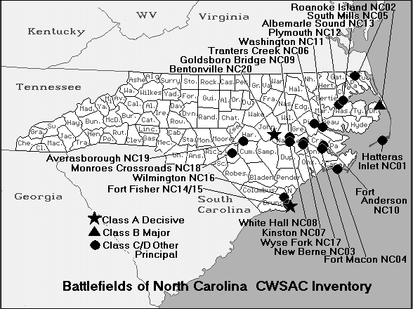
| North Carolina Civil War Map of Battles |
|
| Western North Carolina and the Civil War |
Defense of Western North Carolina
All the major battles fought in North Carolina occurred in the Coastal and Piedmont regions, but although the mountains
were spared the pitched battles, the region was subjected to continuous raiding by bushwhackers and guerrillas.
To confront the large Union armies converging
on the State of Virginia when the war began in 1861, most Southern states, including North Carolina, had been compelled
to move most of their regiments and battalions to her defense. Gen. Robert E. Lee had to make very difficult decisions during
the war, and exigencies were sometimes decided simply on the lesser of the two evils. In 1861-62, Lee, according to D.H.
Hill. Jr., remained fearful that Gen. Ambrose Burnside, having already secured the North Carolina coast, would find out the defenseless condition of North Carolina and forward his troops
toward Raleigh. So each night Lee telegraphed officials in Raleigh to inquire if any enemy movement had been
seen in the area that day.
At the close of 1862, only two regiments of
infantry were left in North Carolina, the Fiftieth and Fifty-first, and the Union forces on the coast could, had they been
apprised of the heavy movement of troops, according to D.H. Hill Jr., "have swept without opposition over all the State. A
people less brave and less patriotic would never have consented to incur such a risk with so strong an enemy at its doors.
The governor exposed his own capital to save that of the Confederacy." More battles were fought in Virginia than
in any other state, which is the reason that North Carolina kept some forty regiments there until the conflict
concluded in 1865.
During the first eighteen months
of the Civil War, 1861-1862, the Union strategy was to blockade the entire Southern coastline while simultaneously
securing its major ports and forts. To accomplish its objectives, the Union military would unleash 24 hour naval bombardments
while conducting amphibious landings at strategic locations along the Old North State's shores. By the end of 1862,
with the exception of Wilmington and Fort Fisher, North Carolina had suffered the loss of practically every major fort
and port city as the combined Union army and navy quickly suppressed the State's mosquito fleet and few troops available to
defend the region. From the State's forts spanning along the barrier islands to those fortresses and earthen works
defending the inland port cities along the Albemarle, Currituck and Pamlico sounds, all, with the exception of few, had
been lost to the Union in the initial eighteen months of the conflict.
With the scant Confederate military quickly
removed from the coast, the Union army would unleash a series of expeditions and raids by pushing inland and burning
bridges and tearing up railroads as its principal objectives.
Early
in the Civil War, William Holland Thomas,
a Cherokee chief, Confederate colonel, and senator, believed that employing guerrilla warfare in an grand strategy to defend the familiar Southern terrain against large advancing Union armies
marching in lockstep rank and file formations, similar to the British during the American Revolution, was the plausible
approach in forcing Washington to sue for peace. He maintained the conviction that any effort employed by the Confederacy
to take the war into the North and to meet and fight them on the battlefield of attrition was doomed before its application.
Lacking any formal
military education, alongside the exigencies of war and the political infighting of the Confederate generals at
Richmond, Thomas' strategy was never taken seriously. While Thomas never adhered to the boastful doctrine that a good Southerner could
whip ten Yankees, he, however, had been adopted and raised by a Cherokee chief who had taught Thomas that to understand the
enemy is to understand the art of tracking and hunting wildlife such as bear, mountain lions, and dear.
To
defend the mountains, Confederate President Jefferson Davis wrote a letter of confidence, dated January 4, 1865, in Thomas' Legion for the task, but in 1865, with all Confederate forces fighting in Virginia
and only a skeleton force left to defend an extremely thin gray line across Southern Appalachia, it was far too
little and perhaps four years too late. In the closing acts of the conflict, Union General George Stoneman led a mounted force of nearly 6,000 troops, known as Stoneman's Raid, throughout the North Carolina and southwestern Virginia mountains, destroying bridges and also nonmilitary
assets, while plundering and stealing from civilian households as they traversed back and force between Old Carolina
and Virginia.
Exigencies of war often
require difficult decisions to be made, and in 1864 Gen. Jubal Early's Army of the Valley required the majority
presence of both the Department of East Tennessee and Western District of North Carolina for the fighting in the Shenandoah
Valley. By transferring the commands to Early, it left only a skeleton force to police the vast mountains from an already
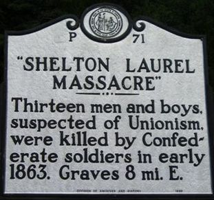
dominant presence of bushwhackers and bands of deserters and outliers. The Shelton Laurel Massacre was a mountain tragedy that revealed the region's lawlessness and anarchy, while Goldman Bryson's Union Volunteers, a Home Yankee unit, showed that divided loyalties and old feuds can unleash all the maledictions of Civil War upon communities
that were once called home.
| Governor Zebulon Vance |
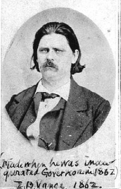
|
| (A Western North Carolina Native) |
Western North Carolina and East Tennessee
Many East Tennesseans and Western
North Carolinians served in the same units during the war, and while the two regions shared a common border, they
also had many similarities. East Tennessee was the poorest of Tennessee's three regions, and within Tennessee, it too possessed the least amount of
slaves. Both regions were of rugged mountain terrain and they experienced high levels of lawlessness while feuds
and bushwhackers were generally the common foe. Together, the common regions often found their men on the same battlefield
while fighting against a larger Union force that had pushed into the area.
The Confederate Armory at Asheville provided the Confederacy with Enfield-style muskets, while Camp Vance was one of the numerous recruiting and training facilities in the North Carolina
mountains. From Asheville, arms and equipment would often be hauled by wagon to the railroads of East Tennessee, where trains
could rapidly transport the much needed war materials into southwestern Virginia or west toward Knoxville, Nashville,
and beyond.
From the East Tennessee
homesteads to the mountain communities, thousands of soldiers served in the Confederate military and fought to defend the large mountain area from a common foe. The highlanders
of Old Carolina fought from the first Civil War battle, at Bethel, to Gettysburg, and many were present
with Lee when he surrendered at Appomattox Court House in April of 1865. While
the average Civil War regiment mustered 1,000 soldiers, North Carolina's sole legion, Thomas' Legion, which recruited mainly from the mountains, had at times fielded
more than 2,500 soldiers, including Cherokee Indians.
| Cold Mountain |
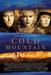
|
| (A Civil War Novel) |
Zebulon Vance, a native of western North Carolina, arrived in Washington at the age 28 and was
the youngest member of Congress and one of the strongest Southern supporters of the Union. In March of 1861, however, when
indications reflected that the North Carolina legislature was going to vote for secession, Vance resigned his seat, returned home, and soon was elected as North Carolina's governor in 1862 and reelected
in 1864. (North Carolina Governors.) The young Vance was known throughout the Southern states as the "War Governor of
the South," not because he was a war hawk, but because of his ability to wisely manage the state even during its most tumultuous
hour. Many believed that the most remarkable Vance policy was his insistence of the rule of law in the midst of the devastation
and confusion of Civil War. Prior to governorship, Vance commanded the valiant 26th North Carolina Infantry, a mountain regiment of fame, and fought in many battles.
The real Private W. P. Inman,
portrayed by Jude Law in the award winning movie Cold Mountain, was a Haywood County highlander who served
in Company F, Twenty-fifth North Carolina Infantry, and several of his brothers served in the Twenty-fifth and Sixty-second North Carolina Regiments. The author of the 1997 novel Cold Mountain, Charles
Frazier, is also a native of the Mountain Region.
Forming part of the Blue
Ridge Mountains within the larger Appalachian Mountains, the Great Balsam Mountains is host to Cold Mountain. Within the mountains, Cold Mountain is nestled within the Shining Rock Wilderness of the Pisgah National Forest about 15
miles southeast of Waynesville and 35 miles south of Asheville. The mountain, which is uninhabited, lies completely within
federal lands and rises to 6,030 feet above sea level, and it is the 40th tallest mountain in the eastern United States.
See also Civil War LeMat Revolver and Cold Mountain.
When hostilities ended in 1865, Vance, Inman, Stringfield, and many
other mountaineers struggled to rebuild the many communities that had been affected by four years of war. Reconstruction
ended in 1877, and although the Gilded Age followed, it was an era of poverty and industrial growth for the nation.
While factories, railroads, and coal signaled an economic boom, which meant jobs, only a small percentage enjoyed the
era's enormous wealth, but poverty continued to plague many areas of the nation, particularly since factories, coal,
railroads, and later oil, were specific only to a few regions of the United States. Immigration from China and Europe
caused a rapid population growth in California and along the East Coast, but the rural areas, being absent the rapid technological
growth enjoyed by many urban communities, continued to struggle for employment.
Wealthy industrialists and financiers of the age, such as John
D. Rockefeller, Jay Gould, Henry Clay Frick, Andrew W. Mellon, Andrew Carnegie, Henry Flagler, Henry H. Rogers, J. P. Morgan,
Leland Stanford, Charles Crocker, Cornelius Vanderbilt were often labeled "robber barons" by their critics, who argued their
fortunes -- which ranged from shipping, railroads, banking, steel, construction, and oil -- were made
by creating monopolies and at the expense of the poor-working class. As the Gilded Age concluded to make way for the Progressive
Era, one known ex-Confederate, as they were often called, said that, "The men of the old Legion are not ashamed of their Confederate record and there is no bitterness to our late foe."
Words of Lt. Col. William Stringfield, Thomas' Legion, May 10, 1901.
Mountain Slavery
Southern Appalachia consists of portions of the states
of Virginia, North Carolina, Alabama, Georgia, South Carolina, Tennessee, West Virginia, Kentucky, and Maryland.
In North Carolina, Southern Appalachia refers only to the State's Mountain Region.
The 1860 U.S. census records indicate that Western
North Carolina was home to four slave owners who each owned 100 or more slaves. According to the census, the wealthiest
slave owner in Buncombe County, which hosted Asheville the region's political and financial center, was Nicholas Woodfin
who owned 122 slaves and had a total wealth of $165,000, making him 1 of the 25 richest plantation owners in
Southern Appalachia. There were a total of 4 slave owners in Western North Carolina who, each owning
more than 100 slaves, were numbered among the top 25 wealthiest planters in Southern Appalachia: 4th wealthiest planter, owning 175 slaves, was W.F.
McKeson of Burke County; 14th wealthiest planter, Nicholas Woodfin, 122 slaves, Buncombe County; 15th wealthiest planter
was Jacob Harshaw, Burke County, who owned 121 slaves; and rounding out the list for WNC as the 22nd wealthiest
planter in Southern Appalachia was Colonel Issac Avery of Burke, owning a total of 103 slaves.
In 1860, Western North Carolina
produced only a negligible quantity of corn, wheat, and tobacco, but not a trace of cotton. The region's livestock
consisted of hogs, cattle, sheep, and horses/mules. WNC's slaves labored mainly in the fields of agriculture, while
a small percentage engaged in commerce and industry. After emancipation 8 out of 10 slaves chose to remain and work for their former masters. See also North Carolina Census.
Western North Carolina by Census Numbers
In 1860, Western North
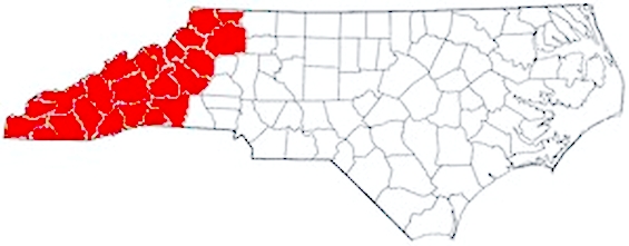
Carolina was made up of 18 mountain counties while the State of North Carolina consisted of 86 counties. Today
the State is divided into 100 counties.
Western
North Carolina consisted of 18 counties in 1860, but it added 3 mountain counties in 1861 for a total of 21.
Although created after the 1860 U.S. census, the 3 newly formed mountain counties were carved from existing
counties so they had no impact on the 1860 population. The 3
added in 1861 were Clay County (formed from part of Cherokee County), Mitchell
County (formed from parts of Burke, Caldwell, McDowell, Watauga, and Yancey counties), and Transylvania County (formed from
parts of Henderson County and Jackson County).
|
County
|
Total
Pop. |
White |
Free Blacks |
Slaves |
|
Alleghany |
3590
|
3351 |
33 |
206 |
|
Ashe |
7956
|
7423 |
142
|
391 |
|
Buncombe |
12654
|
10610 |
111 |
1933 |
|
Burke |
9237
|
6645 |
221
|
2371 |
|
Caldwell
|
7497
|
6295 |
114
|
1088 |
|
Cherokee* |
9166
|
8609 |
38 |
519 |
|
Haywood |
5801
|
5474 |
14
|
313 |
|
Henderson
|
10448
|
8981 |
85
|
1382 |
|
Jackson** |
5515
|
4179 |
6 |
268 |
|
Macon* |
6004 |
5370 |
115 |
519 |
|
Madison
|
5908 |
5678 |
17 |
213 |
|
McDowell |
7120 |
5542 |
273 |
1305 |
|
Polk* |
4043 |
3317 |
106 |
620 |
|
Rutherford |
11573 |
9059 |
123 |
2391 |
|
Surry |
10380 |
8950 |
184 |
1246 |
|
Watauga |
4957
|
4772 |
81 |
104 |
|
Wilkes |
14749 |
13280 |
261 |
1208 |
|
Yancey |
8655 |
8226 |
67 |
362 |
Total
145,253** 125,761 1,991 16,439
*The 1860 U.S. census does not include the Cherokee Indians in Cherokee,
Macon, and Polk counties, but additional census records of the same year show 26 Cherokees in Cherokee County, 55 Cherokees in Macon County, and 5 Cherokees in Polk County.
**The 1860 U.S. census includes the 1062 Cherokees in Jackson County.
| 1860 North Carolina Slave Population Map |
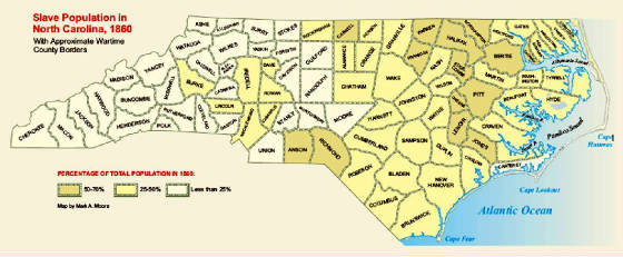
|
| (Click to Enlarge) |
Notes:
Lengthy volumes have been written by many well-intentioned authors and historians
who have strived at great lengths to explain Western North Carolina's loyalties during the Civil War. Many works circulating
on the subject include chapters on statistics and percentages to purport their position on whether or not the region supported
the Union or Confederacy. Some emphasize in their exhaustive work that because most mountain families didn't own a single
slave they obviously favored the Union, but others are in the camp wholeheartedly with the Confederate cause and state
that whereas most Western Carolinians never owned a slave nor cared for the institution of slavery itself, the mountain citizens
held strong convictions of esteeming and placing family and community first.
In the 1800s, conversations among Carolina kin tended to focus
mainly on the family and local community and not on meaningless, abstract events in Washington nor on alien, foreign affairs
which lacked relevance to the welfare and wellbeing of the family and local social network. The mountain community consisted
of several generations of familiar surnames and family ties that had remained unbroken for a century or more.
Because both transportation and media were lacking during the era, the mountain
hometown was isolated from the rest of nation, and while every foreign nation remained alien, local gossip traveled at telegram
speed as it quickly made its short distance to the local market and nearby favorite fishing hole.
Lt. Col. W.W. Stringfield had commanded the infantry regiment of Thomas'
North Carolina Legion for much of the Civil War, and in his memoirs he wrote a few short sentences describing the sentiment
and motives of the soldiers who had served and even died while in service of the Confederate army. Regardless of profession
prior to the conflict, Stringfield said of the Western North Carolinian that when the Union troops invaded their community,
they fought only to repel them.
Recommended Reading: Bushwhackers, The Civil War in North Carolina: The
Mountains (338 pages). Description: Trotter's
book (which could have been titled "Murder, Mayhem, and Mountain Madness") is an epic backdrop for the most horrific
murdering, plundering and pillaging of the mountain communities of western North Carolina during the state’s darkest
hour—the American Civil War. Commonly referred to as Southern Appalachia, the North Carolina
and East Tennessee mountains witnessed divided loyalties in its bushwhackers and guerrilla
units. These so-called “bushwhackers” even used the conflict to settle old feuds and scores, which, in some cases,
continued well after the war ended. Continued below...
Some bushwhackers were highly organized ‘fighting
guerrilla units’ while others were a motley group of deserters and outliers, and, since most of them were residents
of the region, they were familiar with the terrain and made for a “very formidable foe.” In this work, Trotter
does a great job on covering the many facets of the bushwhackers, including their: battles, skirmishes, raids, activities,
motives, the outcome, and even the aftermath. This book is also a great source for tracing ancestors during the Civil War;
a must have for the family researcher of Southern Appalachia. "[T]he historical events that transpired in the region are brought to life in this
study."
Advance to:
Editor's Pick:
The Secret of War: A Dramatic History of Civil War Crime in Western North Carolina,
by Terrell T. Garren. Description: Civil War crime in western North Carolina is the subject of The Secret of War, by Terrell T. Garren. Based on the true-life
experience of Delia Russell Youngblood, the great-grandmother of the author, the book "captures what the Civil War was like
in the mountains and throughout the south." After hearing his great-grandmother's story, Garren spent nearly fifteen years
researching this story in particular and the Civil War history of western North
Carolina in general. It is the story of Joseph Youngblood and Delia Russell of Hoopers Creek in Henderson County, North Carolina. Continued
below…
The reader will follow Joseph
through his enlistment as a part of Company H, the "Cane Creek Rifles," of the 25th North Carolina Infantry Regiment to the
Battle of Malvern Hill, Virginia, and to battle in Sharpsburg, Maryland, where
he was captured. Taken to the Union Camp Morton in Indianapolis, Indiana,
he finally escapes and makes his way down the Ohio and Mississippi
rivers into Mississippi. Attempting to make his way back
to North Carolina, he is in Dalton, Georgia, in May of 1864 when fourteen Confederate soldiers, including a brother,
are executed for "desertion." Ultimately, being recaptured, he goes back to Camp
Morton until the end of the war. Told with historical accuracy, names,
battles, and places in this story are true to fact. Readers will recognize place names in Henderson,
Jackson, Haywood, Cherokee, Transylvania, Clay, Macon, and Buncombe Counties in North
Carolina. Family names mentioned include Fletcher, Carland, Lewis, Bishop, Bryson, Freeman, Henderson,
Fowler, Whitaker, Wheeler, Summey, Russell, Barnwell, Ward, Lanning, Hammond, Garren, Youngblood, and Blake. What sets this book apart from many, however, is the story of what happened to
the women left behind at home. The story reveals how the lowest criminal element found its way into the Union Army. Many mountain
men motivated by greed and an awareness of the demise of Confederate authority signed up with no interest in any cause but
their own. Union officers who enter the picture include Generals George Stoneman, Alavan C. Gillem, and William J. Palmer.
Palmer enters the story late but emerges as a man of genuine integrity and selfless bravery opposed to and fighting this element
in his own army. About the Author: Terrell T. Garren is an eighth generation western North Carolinian. He was born in Asheville, North Carolina, in 1951.
He earned his B.S. and M.A. degrees from Western Carolina
University in Cullowhee, North Carolina. A resident of Henderson County,
North Carolina, he has been a commercial writer for twenty years.
Dr. Newton Smith of Western
Carolina University says, "The Secret of War" is that rare historical novel that captures both the romance and the grit and
gore of war on the home front without distorting the history. It is about time someone did the story of the Civil War in the
southern mountains right."
Rob Neufeld, writing in
the Asheville (NC) Citizen-Times, has said the book "is a must read" and "as a contribution to our understanding of the most
disturbing passage in our history, it is indelible." He further writes, "Fiction? It really happened; and, if it hadn't, the
author wouldn't be around to tell it....Although Garren has written fiction, he wants you to treat it as history. After all,
at the back of his book, he provides an index."
Recommended Reading: The Civil War in North Carolina: Soldiers' and Civilians'
Letters and Diaries, 1861-1865. Volume 2: The Mountains (Civil War in North Carolina)
(Hardcover). Description: As with The Civil War in North Carolina: Soldiers' and Civilians' Letters
and Diaries, 1861-1865. Vol. 1: The Piedmont, this work presents letters and diary entries (and a few other documents) that tell the experiences of soldiers and
civilians from the mountain counties of North Carolina during
the Civil War. The counties included are Alleghany, Ashe, Buncombe, Burke, Caldwell, Cherokee,
Clay, Haywood, Henderson, Jackson, McDowell, Macon,
Madison, Mitchell, Polk, Rutherford, Surry, Transylvania,
Watauga, Wilkes, and Yancey. The book is arranged chronologically, 1861 through 1865. Before each letter or diary entry, background
information is provided about the writer. Continued below...
The Civil War
in North Carolina: Soldiers'
and Civilians' Letters and Diaries, 1861-1865 (Volume 2): The Mountains, is the soldier's story. It is an A-to-Z compilation
of what the "rank and file soldier" experienced during the American Civil War. The Western
North Carolina soldiers express their hearts to their loved ones and friends, thus allowing the reader
the most intimate and personal view of the war. From triumph to tragedy, the "soldiers' letters" express what few authors
or writers can achieve--realism. According to cartographic and demographic studies, Southern
Appalachia comprised a unique indigenous people, and by isolating these rare letters it allows the
reader the most detailed insight to their experiences. The soldier experienced various traumatic stressors in the conflict:
such as witnessing death or dismemberment, handling dead bodies, traumatic loss of comrades, realizing imminent death, killing
others and being helpless to prevent others' deaths. Plain, raw and to the point: The
reader will witness the most detailed insight to the so-called American Civil War. Intimate and personal: diseases, privation,
wounds, loneliness, exhaustion, heartache, and death are all explored. This book includes a lot of information about: Western North Carolina Civil
War History (North Carolina mountain troops), soldiers' photos (some
tintype photographs too), and rare pictures. For example, on page 143, there is a photo of Gov. Zeb Vance's brother,
Robert, at Fort Delaware Prisoner of War Camp; he had been captured by Pennsylvania cavalry in East Tennessee. You may see
a rare photo or letter of an ancestor. The maps, which reflect the region, have keys which place each regiment
to each respective western county (where the troops were raised). The soldiers - collectively - also
present a detailed North Carolina Civil War History. By reading the letters, you will easily form a timeline that is
filled with first-hand facts. To be very candid, it is not only filled with primary accounts of the war, but it is one
of the best books to read about the war...Creates an indispensable historical timeline of events of the brave
men from the Old North State.
Recommended
Reading: Remembering North Carolina's Confederates (NC) (Images of America). Description: The
American Civil War was scarcely over when a group of ladies met in Raleigh
and began to plan commemoration for the honored Confederate dead of North Carolina. In 1867, they held their first memorial service.
Two years later in Fayetteville,
the first monument to the state's fallen Confederate soldiers was erected. Over the next 14 decades, countless monuments were
commissioned in cemeteries and courthouse squares across the state. Continued below…
Following Reconstruction,
the veterans themselves began to gather in their local communities, and state and national reunions were held. For many of
the Confederate veterans, honor for their previous service continued long after their deaths: accounts of their sacrifice
were often chiseled on their grave markers. The numerous images within this book, photographs of veterans and reunions, monuments,
and tombstones are but a sampling of the many ways that the old Confederate soldiers are commemorated across the Old North State.
About the Author: Historian and photographer Michael C. Hardy is truly one-of-a-kind; he has dedicated and sacrificed his
life preserving North Carolina’s
Civil War history and heritage. With unmatched zeal and enthusiasm, Michael travels thousands of miles annually, while crisscrossing
North Carolina, teaching, educating, speaking, listening,
researching, and reading every conceivable aspect of the Civil War as it relates to the Old North State.
Michael C. Hardy is the author of numerous books and articles about North Carolina's role during the Civil War. This is his second book
for Arcadia Publishing. A popular speaker for history associations, preservation groups, and museums, he lives with his wife,
Elizabeth, and son, Nathaniel, in the mountains of Western North Carolina.
Recommended Reading:
Touring the Western North Carolina Backroads (Touring the Backroads). Editorial
Review: This guidebook, unlike most, is so encyclopedic in scope that I give it as a gift to newcomers to the area. It is
also an invaluable reference for the visitor who wants to see more than the fabulous Biltmore Estate. Even though I am a native
of the area, I learned nearly everything I know about Western North Carolina from this book
alone and it is my primary reference. I am still amazed at how much fact, history and folklore [just enough to bring alive
the curve of the road, the odd landmark, the abandoned building] is packed in its 300 pages. Continued below...
The author, who must have collapsed from exhaustion when
she finished it, takes you on a detailed tour, laid out by the tenth of the mile, of carefully drawn sections of backroads
that you can follow leisurely without getting lost. The
author is completely absent from the text. The lucid style will please readers who want the facts, not editorial comment.
This book, as well as the others in this publisher's backroads series, makes an excellent gift for anyone, especially the
many seniors who have relocated, or are considering relocating to this fascinating region. It is also a valuable reference
for natives.
About: Western North Carolina American Civil War History; The
Mountains of North Carolina - Southern Appalachia - and the American Civil War. Census
facts provided United States Census online and University of Virginia Library.
|
