|
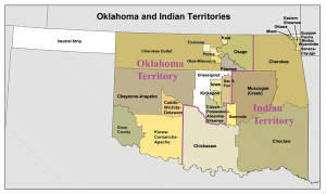
| Oklahoma Territory and Indian Territory Map |
|
| Oklahoma and Indian Territory Map |
Oklahoma Territory
was an organized territory of the United States from May 2, 1890, until
November 16, 1907, when Oklahoma became the 46th state.
It consisted of the western area of what is now the State of Oklahoma.
The eastern area consisted of the last remnant of Indian Territory. The Indian Territory,
also known as The Indian Country, The Indian territory or the Indian territories, was land set aside within the United States for the use of Native Americans. The general
borders were set by the Indian Intercourse Act of 1834. The Indian Territory was gradually reduced to what is now Oklahoma; then, with the organization of Oklahoma
Territory in 1890, to just the eastern half of the area. The citizens
of Indian Territory tried, in 1905, to gain admission to the union as the State of Sequoyah,
but were rebuffed by Congress and Administration who did not want two new Western states, Sequoyah and Oklahoma. Citizens then joined to seek admission of a single state to the Union.
With Oklahoma statehood in November 1907, Indian Territory
was extinguished. Many Native Americans continue to live in Oklahoma,
especially in the eastern part.
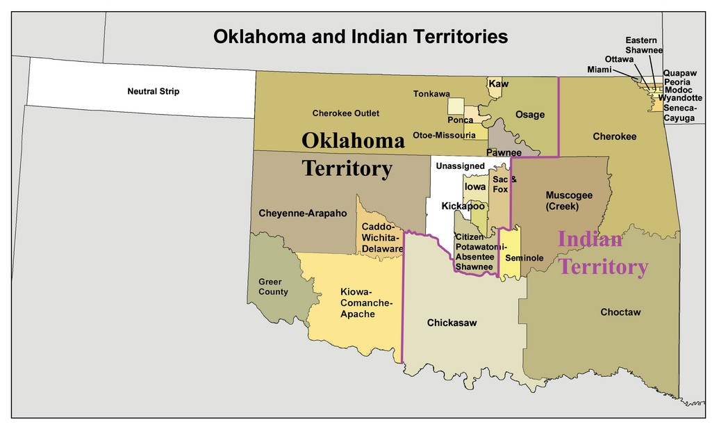
| Map of the Oklahoma and Indian Territory |
|
| Oklahoma and Indian Territories, 1890s |
The greatest impetus for Oklahoma
statehood began after the Land Run of 1889. Approximately fifty thousand non-Indian settlers made the run on April 22, 1889,
into the Unassigned Lands (Oklahoma District). They began immediately to clamor for statehood in order to gain representation
in Congress. The Organic Act of 1890 established a territorial government for Oklahoma
Territory and defined the boundaries of Oklahoma Territory (O.T.) and Indian Territory
(I.T.) comprising present Oklahoma. The law also called
for the election of a non-voting delegate from O.T. to the U.S. House of Representatives.
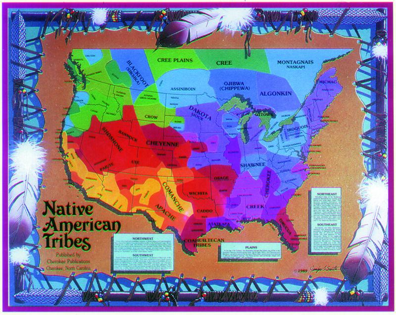
| Map of Native Americans |
|
| Map of Native American Tribes |
Before the passage of the
Oklahoma Enabling Act (1906), four statehood plans evolved. They included single statehood, double statehood, piecemeal absorption,
and admission of O.T. to the Union without regard to I.T. Single statehood involved the joining of the two territories, whereas double
statehood meant separate statehood for each territory. Numerous statehood conventions were held in O.T. and I.T. from 1891
to 1905.
Of significance was the
meeting called in 1903 at Shawnee, when delegates formed the Single Statehood Executive Committee
and elected Charles G. Jones of Oklahoma City as chair. This
group lobbied for three years until the Enabling Act was passed in 1906. At the first statehood convention, held in Oklahoma City on December 15, 1891, delegates favored single statehood
and wrote a memorial to Congress.
Consequently, in 1892 David A. Harvey, the first territorial delegate,
submitted the memorial and introduced an unsuccessful bill in Congress calling for single statehood. Among those who favored
the bill were Oklahoma City's Sidney Clarke of Oklahoma
City and Guthrie's Horace Speed and William P. Hackney. Opposing the bill were Elias C. Boudinot (Cherokee),
Roley McIntosh and Albert P. McKellop (Creek), and J. S. Standley (Choctaw). In 1902 delegate Dennis T. Flynn advocated a
piecemeal absorption approach, asking for immediate statehood for O.T., with individual Indian nations in I.T. added to the
state as they became ready for statehood.
The driving forces of politics
and economics created an ever-changing situation and caused individuals to waver in their support of the different
statehood plans. For example, Sidney Clarke initially favored single statehood but later supported statehood for O.T. with
I.T. added at a future date. At the national level, opposition arose in Congress from eastern representatives who were concerned
that the admission of O.T. would overturn their supremacy by increasing the number of western states. Southern Democratic
representatives worried that O.T. would enter the Union with a strong Republican following.
Others argued that the land area of O.T. was too small to be considered a state and that its resources of agriculture and
cattle raising were too limited. Also, there would be no tax base to support a state government for five years, because homesteaders
were required to live on their claims for five years before receiving title to the land. Therefore, no taxes could be generated
until 1894. In addition, allotments to American Indians in O.T. were held in trust by the federal government for twenty-one
years and were exempt from taxes.
| Map of Native American Tribes |
|
| Native American Tribes' Map |
| (Map) Plains Indians at time of European contact |
|
| Oklahoma and Indian Territory Map |
Generally, American Indians opposed federal attempts to organize them as a
territory or a state. They wanted to retain their tribal governments and to continue their communal land ownership. Prior
to the agitation for statehood in the 1890s, events in I.T. caused distress among the Five Civilized Tribes. As early as 1854 Arkansas Sen. Robert W. Johnson introduced a bill calling
for the division of the Five Civilized Tribes's domain into three territories, allotting land in severalty to the American
Indians, and selling surplus lands to non-Indian settlers. Later the three territories would be joined to form the state of
Neosho.
In the 1860s the federal government initiated steps toward governing the American Indians. Because some members of the Five
Civilized Tribes supported the Confederacy during the Civil War, the tribes were required to sign new treaties with the United States after the war. The Reconstruction Treaties of
1866 and federal Indian policy envisioned the formation of an Indian territorial government. To thwart this, representatives
of the I.T. nations met at Okmulgee, Creek Nation, in 1870
and drafted the Okmulgee Constitution, which provided for an elected governor, a bicameral legislature, and a court system.
Although the document was not ratified by I.T. voters, the event gave American Indian leaders experience that they applied
during the future Sequoyah Convention.
As whites continued to move into I.T., their numbers increased from
110,254 in 1890 to 302,680 in 1900. They outnumbered American Indians by a ratio of 3 to 1 in 1890 and a ratio of 6 to 1 in
1900. While the Five Civilized Tribes retained their sovereignty, whites could not own land or vote. Whites complained of
an inadequate justice system. Generally, no education for their children was available other than through subscription schools.
Whites continued to follow party politics and attended national conventions, because they believed that I.T. would soon become
a state. With statehood, a number of political offices would be offered to prominent party leaders.
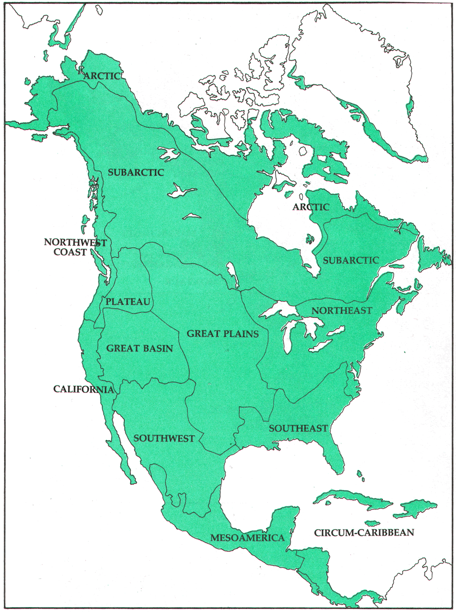
| Map of the American Regions and Areas |
|
| American Indians inhabited North America prior to European contact |
As agitation for statehood continued in the 1890s, American Indian leaders
and whites in Indian
Territory (I.T .) favored double statehood. Indian leaders feared that if I.
T. were added to O. T. to form one state, they would be outmaneuvered by the dominant political power in O.T. However, business
owners in I.T. opposed double statehood, because they believed they would receive the brunt of the tax burden, as American
Indian land allotments would not be taxed for twenty-one years. When it became apparent that double statehood would not occur,
whites clamored for the joining of the two territories to form a state.
Several events in the 1890s brought I.
T. closer to statehood. In 1893 the Indian Appropriation Bill called for the Dawes Commission to meet with the Five Civilized
Tribes to start the allotment process. Through the Atoka Agreement, ratified in 1897, the Choctaw and Chickasaw Nations agreed
to take their lands in severalty. In 1898 Congress passed the Curtis Act, which called for the abolishment of tribal governments
on March 6, 1906. Realizing that their governments would soon be defunct, leaders of the Five Civilized Tribes convened the
Sequoyah Convention in August 1905 in Muskogee to write a
constitution and to write a memorial to Congress for separate statehood for I.T .
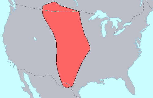
| Great Plains Tribes |
|
| Native American Plains Indians |
(Left) Map of the Great
Plains
The Sequoyah Convention constitution was not acknowledged by the U.S. Congress,
due to party politics. Indian Territory was bordered by two southern Democratic states, Arkansas to the east and Texas to the south. Consequently, Pres. Theodore Roosevelt, a Republican, and the Republican-controlled
Congress wanted joint statehood to eliminate the possibility of I.T. joining the Union as
a Democratic state. On June 16, 1906, President Roosevelt signed the Oklahoma Enabling Act, which provided for the writing
of a constitution for a state to be formed from the merging of Indian and Oklahoma
territories.
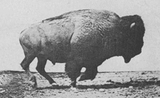
Plains Indians are usually
divided into two broad classifications which overlap to some degree:
The first group
of Plains Indians was fully nomadic, following the vast herds of buffalo. Some tribes occasionally engaged in agriculture;
growing tobacco and corn primarily. These included the Blackfoot, Arapaho, Assiniboine, Cheyenne,
Comanche, Crow, Gros Ventre, Kiowa, Lakota, Lipan, Plains Apache (or Kiowa Apache), Plains Cree, Plains Ojibwe, Sarsi, Shoshone,
Stoney, and Tonkawa.
The second group of Plains
Indians (sometimes referred to as Prairie Indians) was the semi-sedentary tribes who, in addition to hunting buffalo,
lived in villages and raised crops. These included the Arikara, Hidatsa, Iowa, Kaw (or Kansa),
Kitsai, Mandan, Missouria, Omaha, Osage, Otoe, Pawnee, Ponca,
Quapaw, Santee, Wichita, and Yankton.
(Sources listed at bottom of page.)
Recommended
Viewing: 500 Nations
(372 minutes). Description: 500 Nations is an eight-part documentary (more than 6 hours and that's not including its interactive CD-ROM filled
with extra features) that explores the history of the indigenous peoples of North and Central America, from pre-Colombian
times through the period of European contact and colonization, to the end of the 19th century and the subjugation of the Plains
Indians of North America. 500 Nations utilizes historical texts, eyewitness
accounts, pictorial sources and computer graphic reconstructions to explore the magnificent civilizations which flourished
prior to contact with Western civilization, and to tell the dramatic and tragic story of the Native American nations' desperate
attempts to retain their way of life against overwhelming odds. Continued below...
Mention the word "Indian," and most will conjure up images
inspired by myths and movies: teepees, headdresses, and war paint; Sitting Bull, Geronimo, Crazy Horse, and their battles
(like Little Big Horn) with the U.S. Cavalry. Those stories of the so-called "horse nations" of the Great Plains are all here, but
so is a great deal more. Using impressive computer imaging, photos, location film footage and breathtaking cinematography,
interviews with present-day Indians, books and manuscripts, museum artifacts, and more, Leustig and his crew go back more
than a millennium to present an fascinating account of Indians, including those (like the Maya and Aztecs in Mexico and the
Anasazi in the Southwest) who were here long before white men ever reached these shores.
It was the arrival of Europeans
like Columbus, Cortez, and DeSoto that marked the beginning of the end for the Indians. Considering the participation of host
Kevin Costner, whose film Dances with Wolves was highly sympathetic to the Indians, it's no bulletin that 500 Nations also
takes a compassionate view of the multitude of calamities--from alcohol and disease to the corruption of their culture and
the depletion of their vast natural resources--visited on them by the white man in his quest for land and money, eventually
leading to such horrific events as the Trail of Tears "forced march," the massacre at Wounded Knee, and other consequences
of the effort to "relocate" Indians to the reservations where many of them still live. Along the way, we learn about the Indians'
participation in such events as the American Revolution and the War of 1812, as well as popular legends like the first Thanksgiving
(it really happened) and the rescue of Captain John Smith by Pocahontas (it probably didn't).
NEW! Recommended Viewing: We
Shall Remain (PBS) (DVDs) (420 minutes). Midwest Book Review: We Shall Remain is a three-DVD thinpack
set collecting five documentaries from the acclaimed PBS history series "American Experience", about Native American leaders
including Massasoit, Tecumseh, Tenskwatawa, Major Ridge, Geronimo, and Fools Crow, all who did everything they could to resist
being forcibly removed from their land and preserve their culture. Continued below...
Their strategies ranged from military action to diplomacy, spirituality,
or even legal and political means. The stories of these individual leaders span four hundred years; collectively, they give
a portrait of an oft-overlooked yet crucial side of American history, and carry the highest recommendation for public library
as well as home DVD collections. Special features include behind-the-scenes footage, a thirty-minute preview film, materials
for educators and librarians, four ReelNative films of Native Americans sharing their personal stories, and three Native Now
films about modern-day issues facing Native Americans. 7 hours. "Viewers will be amazed." "If you're keeping score, this program
ranks among the best TV documentaries ever made." and "Reminds us that true glory lies in the honest histories of people,
not the manipulated histories of governments. This is the stuff they kept from us." --Clif Garboden, The Boston Phoenix.
Recommended
Reading: The Five Civilized Tribes: Cherokee, Chickasaw, Choctaw, Creek,
Seminole (Civilization of the American Indian)
(455 pages: University of Oklahoma Press). Description: Fascinating and captivating study of the often referred to Five Civilized
Tribes, with each tribe's: evolution, struggles, Indian removal, treaties, internal and external strife, and outlook...numerous
maps and photographs compliment this research. Continued below...
By focusing on all 'Five Tribes' it also presents a better understanding of how the tribes interrelated
in the Indian Territory (most of present-day Oklahoma). While most authors only focus on "a tribe"
rather than "the tribes," Foreman, by interconnecting the tribes, conveys a more comprehensive understanding of the Five Nations.
Recommended
Reading: Atlas of the North
American Indian. Description: This unique resource covers the entire history, culture, tribal
locations, languages, and lifeways of Native American groups across the United States,
Canada, Central America, Mexico, and the Caribbean. Thoroughly updated, Atlas of the
North American Indian combines clear and informative text with newly drawn maps to provide the most up-to-date political and
cultural developments in Indian affairs, as well as the latest archaeological research findings on prehistoric peoples. The
new edition features several revised and updated sections, such as "Self-Determination," "The Federal and Indian Trust Relationship
and the Reservation System," "Urban Indians," "Indian Social Conditions," and "Indian Cultural Renewal." Continued below...
Other updated
information includes: a revised section on Canada, including Nunavut, the first new Canadian territory created since 1949,
with a population that is 85% Inuit; the latest statistics and new federal laws on tribal enterprises, including a new section
on "Indian Gaming"; and current information on preferred names now in use by certain tribes and groups, such as the use of
"Inuit" rather than "Eskimo."
Recommended
Reading: Seizing Destiny: The Relentless Expansion of American
Territory. From Publishers Weekly: In an admirable and important addition to his distinguished oeuvre,
Pulitzer Prize–winner Kluger (Ashes to Ashes, a history of the tobacco wars) focuses on the darker side of America's
rapid expansion westward. He begins with European settlement of the so-called New World, explaining that Britain's successful colonization depended not so much on
conquest of or friendship with the Indians, but on encouraging emigration. Kluger then fruitfully situates the American Revolution
as part of the story of expansion: the Founding Fathers based their bid for independence on assertions about the expanse of
American virgin earth and after the war that very land became the new country's main economic resource. Continued below...
The heart of
the book, not surprisingly, covers the 19th century, lingering in detail over such well-known episodes as the Louisiana Purchase
and William Seward's acquisition of Alaska. The final chapter looks at expansion in the 20th century. Kluger
provocatively suggests that, compared with western European powers, the United States
engaged in relatively little global colonization, because the closing of the western frontier sated America's expansionist hunger. Each chapter of this long, absorbing book is rewarding
as Kluger meets the high standard set by his earlier work. Includes 10 detailed maps.
Recommended
Reading: Manifest Destiny:
American Expansion and the Empire of Right
(Critical Issue Book). From Booklist: In this concise essay, Stephanson
explores the religious antecedents to America's
quest to control a continent and then an empire. He interprets the two competing definitions of destiny that sprang from the
Puritans' millenarian view toward the wilderness they settled (and natives they expelled). Here was the God-given chance to
redeem the Christian world, and that sense of a special world-historical role and opportunity has never deserted the American
national self-regard. But would that role be realized in an exemplary fashion, with America
a model for liberty, or through expansionist means to create what Jefferson called "the empire
of liberty"? Continued below…
The antagonism
bubbles in two periods Stephanson examines closely, the 1840s and 1890s. In those times, the journalists, intellectuals, and
presidents he quotes wrestled with America's purpose in fighting each decade's war, which added
territory and peoples that somehow had to be reconciled with the predestined future. …A sophisticated analysis of American
exceptionalism for ruminators on the country's purpose in the world.
Recommended
Reading: Manifest Destiny and Mission in American
History (Harvard University Press). Description: "Before this book first appeared in 1963, most historians wrote as if the continental expansion of
the United States was inevitable.' What
is most impressive,' Henry Steele Commager and Richard Morris declared in 1956, 'is the ease, the simplicity, and seeming
inevitability of the whole process.' The notion of 'inevitability,' however, is perhaps only a secular variation on the theme
of the expansionist editor John L. O'Sullivan, who in 1845 coined one of the most famous phrases in American history when
he wrote of 'our manifest destiny to overspread the continent allotted by Providence
for the free development of our yearly multiplying millions.' Continued below...
Frederick Merk rejected inevitability in favor of a more contingent interpretation
of American expansionism in the 1840s. As his student Henry May later recalled, Merk 'loved to get the facts straight.'" --From the Foreword by John Mack Faragher About the Author: Frederick Merk was Gurney
Professor of American History, Harvard University.
BIBLIOGRAPHY: Thomas H. Doyle, "Single Versus Double Statehood," The Chronicles
of Oklahoma 5 (March, June, and September 1927). Charles Ellinger, "Political and Economic Influences On the Statehood Movement
in Oklahoma" (M.A. thesis, University of Oklahoma, 1960). Charles Wayne Ellinger, "Congressional Viewpoint Toward the Admission
of Oklahoma As a State: 1902-1906," The Chronicles of Oklahoma 58 (Fall 1980). Charles Wayne Ellinger, "The Drive For Statehood
in Oklahoma, 1889-1906," The Chronicles of Oklahoma 41 (Spring 1963). Arrell M. Gibson, Oklahoma: A History of Five Centuries
(2nd ed.; Norman: University of Oklahoma Press, 1981). "Statehood (American Politics) Oklahoma," Vertical File, Research Division,
Oklahoma Historical Society, Oklahoma City, Oklahoma. Dora Ann Stewart, The Government and Development of Oklahoma Territory
(Oklahoma City: Harlow Publishing Co., 1933).
Linda D. Wilson
© Oklahoma Historical Society
|